The Snorrastofa Reykholt history museum has been using a hybrid GPS and ultra-wideband (UWB) active radio frequency identification system to provide a location-based audio guide for each visitor to automatically access content specific to his or her exact location, including in front of a given exhibit. Several companies in Europe, as well as in the United States, are now in discussions with Icelandic software company Locatify to use UWB technology at their own museums or music exhibits to provide fast, precise, location-based information.
Snorrastofa is a medieval history cultural center named after Snorri Sturluson, an Icelandic historian, poet and politician. Among other accomplishments, Snorri authored a book hypothesizing how gods result, over time, from the tales told of dead war leaders. The museum, located in his ancient homestead, offers information about Snorri, as well as some of Iceland’s history, including the mythological gods that drove soldiers to battle. The center also provides history regarding Icelandic literature, crafts and culture. It has been using the GPS data with the associated app for guests, but more recently tested the UWB version of the solution for more precise location indoors.
Locatify was founded in 2009 to provide location-based apps. Initially, its solutions leveraged beacon-based Bluetooth Low Energy (BLE) and GPS to identify a person’s general vicinity based on his or her phone location, and to then forward relevant data accordingly.

The company has been providing its apps for such companies as retailers, special events managers, tourism businesses and museums (see Fire, Ice and Beacons Converge at Eldheimar Museum). The firm’s content-management system enables its customers to develop apps for wayfinding, tourist guides or games. The BLE-based systems employ beacons provided by Kontact.io.
The system also works with beacons from most BLE manufacturers. Locatify leverages GPS data for applications such as tour bus audio guides, for which location data need not be precise, so that tour companies can provide information about the area through which a particular bus is travelling, or a specific attraction near which the vehicle passes.
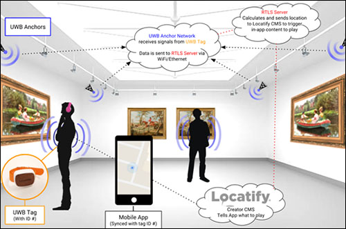
In some cases, however, neither GPS nor beacons provide location information that is sufficiently specific for potential users, explains Sam Liddell, Locatify’s business-development manager. So this year, it released its UWB system, for which Snorrastofa is the first potential customer. The museum installed the Locatify solution, including GPS data to provide location-specific content outdoors, as well as UWB technology indoors where an app user’s location needs to be identified very specifically.
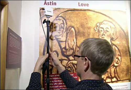
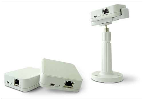
The museum, which spans approximately 1,250 square meters (13,455 square feet), installed five UWB receivers to cover a 218-square-meter (2,346-square-foot) area, which Locatify calls anchors. Locatify developed the anchors, and a third-party provider is manufacturing them according to the company’s specifications.
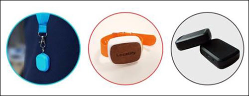
When museum guests arrive, each is provided with a lanyard or wristband version of a Locatify locator tag. The tag transmits its unique ID number at the 6 to 9 GHz UWB frequency, and multiple anchors within its vicinity capture the tag transmissions and forward that data to Locatify’s real-time locating system (RTLS) software, which then identifies the tag’s location within about 20 centimeters (7.9 inches).
The anchors are typically installed in corners, Liddell says, and each can read tags at a distance of up to about 40 meters (131 feet). As a guest walks around the museum, the system identifies that individual’s location based on the tag reads, then relevant content is displayed about each exhibit he or she visits. The system is sensitive enough that the content can vary between exhibits located only a few meters apart.
The system can also come with turn-by-turn wayfinding, Liddell says, though Snorrastofa is not currently using that feature. “We think wayfinding will be a standard feature with the next round of your ultra-wideband [-based solution],” he states. The tag can also be built into a tablet, so that users could simply view the content on a device borrowed from the museum, rather than employing an app on their own phone.
Companies can provide location-based notifications to customers with beacons at a very low cost, Liddell notes, but such systems may lack what he calls “the wow factor.” In some cases, he adds, exhibits are close to each other, users move relatively quickly, and an effective app needs to be able to determine an individual’s location not just within meters, but within inches. In addition, Liddell states, “Beacons have their limitations. If you have a big open space, you can’t have beacons installed everywhere.”
While the UWB anchors themselves are not more expensive than beacons, the tags typically cost about €40 ($47.50) apiece. The system could cost a user considerably more than a beacon-based solution, in which a user’s phone could act as a locating device. However, Liddell notes, if a large room required multiple beacons to accomplish location data, the UWB system would still be more cost-effective. By early next year, Locatify expects to have three pilots under way at other companies in Europe or North America.