Bus passengers in Blacksburg, Va., are locating their bus stops and buses via beacon-based technology. Blacksburg Transit (BT) reports that its BT4U (Blacksburg Transit For You) app, used in conjunction with GeLo beacons attached to buses and bus stops, also collects vehicle usage data to help BT further improve on service.
Blacksburg Transit operates the town-owned bus line, comprising 47 buses and 50 stops, throughout the New River Valley area. In 2014, the agency provided more than 3.6 million passenger trips. Because Virginia Tech‘s campus is located in the town, 95 percent of riders are students, faculty and staff, says Tim Witten, Blacksburg Transit’s manager for intelligent transportation systems (ITS).
“We’ve always tried to make the transit system as easy to use as possible,” Witten says. Most students who attend Virginia Tech have minimal bus-riding experience, he explains, with the exception of school buses. Although the vehicles are clean and typically on time, with friendly drivers, some students, staff and faculty choose to drive to the campus simply because they aren’t certain about schedules and whether a particular bus can get them where they need to be. The BT4U bus is aimed at such potential riders, thereby reducing greenhouse emissions from car use, and freeing up parking spaces on campus.

BT began looking into an app to make ridership easier in 2014, and with a Federal Transit Administration (FTA) grant for greenhouse gas reduction, Witten began investigating beacon-based app solutions. He discovered that several city transit systems have tested beacon systems, but that they did not educate passengers about the beacon technology’s use in advance. Consequently, the adoption by passengers was not as strong as it could have been. In addition, Witten says, he began exploring beacon technology vendors but found that most wanted to sell a full solution, and offered features that the transit authority didn’t want, such as the capability for a beacon to be programmed remotely (something that could expose the system to hackers).
Instead, BT selected two local companies to develop the content-management system residing on the company’s server that would manage data received from and sent to passengers via the app. ACI Web developed the BT4U app, which is based on software provided by Nomad Mobile Guides.
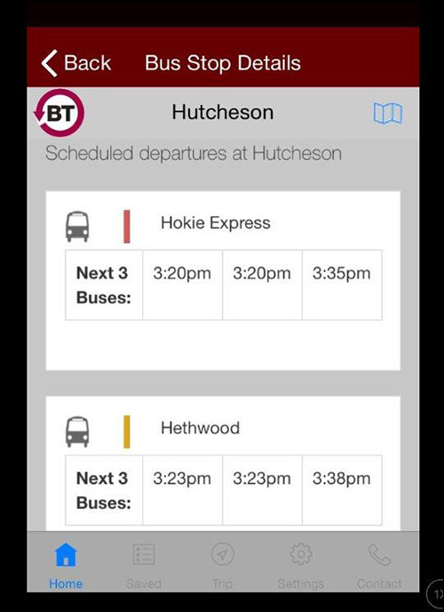
A bus rider first downloads the BT4U app from the iTunes or Google Play website. The app creates a unique ID number for that person’s smartphone, with which it can collect analytical data, and uses the phone’s GPS data to identify the user’s location. He then enters his destination, and the app displays, based on his location, where he can find the closest bus stop for his trip, along with which bus or buses he would need to take in order to reach that destination. He then leaves the app on, and proceeds to that location.
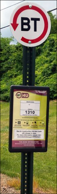
When the user comes within transmission range (20 to 30 feet) of the GeLo beacon installed on a signpost at that bus stop, the app indicates that he has reached the correct location, and also lists the next three buses due to arrive there. Once a bus pulls up, it has a GeLo beacon mounted on it as well, inside the front door. His phone captures that beacon’s transmission, and if the bus is the correct one for that passenger, he receives a notice on the phone. Because the transmission distance is 20 to 30 feet, Witten says, there is little likelihood of a passenger’s phone receiving transmissions from multiple buses simultaneously, since each vehicle is at least 40 feet in length. The app then indicates which stop he should use for his destination.
The system is designed to do more than just help passengers find their way to their destination. Witten also uses it to better understand how many riders there are at specific times, days and locations, as well as when queues might develop at bus stops. The BT4U app not only displays data for the passengers, but also sends the unique ID and app-based data to the content-management software on BT’s server, in order to collect a record of passenger behavior. For instance, if a rider looks up a specific route, that event is captured, and if he actually completes that route, that event is also collected.
According to Witten, this data could prove invaluable in better managing the fleet of buses, as well as where they should be and when. For instance, he states, “We have a rush hour every hour to hour and a half,” based on when classes let out. By better understanding where buses need to be to ensure that long lines don’t develop, BT can improve service to manage that flow of passengers. By making sure the agency doesn’t have too many vehicles traveling in the area, and thereby consuming unnecessary fuel, it can also reduce greenhouse emissions.
All of the data is anonymous, Witten says, and no passenger is tracked—only the ID number related to the phone and app.
The GeLo beacons are designed to be rugged and waterproof, which should enable them to sustain the weather. Witten says he selected the GeLo beacons for the system because they are rugged, and require only a AAA battery that can easily be replaced—he plans to do so every year initially, though typically, the batteries can last for about two years, according to Al Juarez, GeLo’s sales VP.
BT plans to further evaluate the data from the system to better identify bus location. This spring, the app had been installed on approximately 9,740 iOS devices and 3,000 Android devices. The community has a population of about 45,000, Witten says, so this number of app users should provide sufficient ridership data to be very useful. In fact, he estimates that having only about 10 percent of the riders using the app would still generate enough information to be of use regarding when buses or stops become crowded.
BT is also evaluating how Wi-Fi access points with built-in Bluetooth Low Energy (BLE) radios could collect data about buses parked in the 94,000-square-foot garage. Without any automated location data, Witten says, BT’s workers often need to walk around to locate a bus and verify that it is in the garage. With the beacons already installed on the bus transmitting to BLE radios in the Wi-Fi access points, he notes, that information could be collected automatically.
“My first goal is to know if buses are in the garage,” Witten says. This could be accomplished via a few of the BLE-enabled Wi-Fi access points. By installing even more BLE-enabled Wi-Fi access points and programming the software to estimate a location based on that data, he also hopes to identify where in the garage the bus is parked. BT is now testing BLE-enabled Wi-Fi access points from several vendors.
In the future, BT may also look into using the beacon-based ridership data to better understand how effective marketing campaigns are.