Ireland’s Port of Cork is about to begin a trial of a vessel-tracking system that includes radio frequency identification technology, in order to obtain an electronic record of which areas of its seafloor are being dredged, and when. This will ensure that the port continues to upgrade the portage waters at the proper time and place. The RFID technology is part of a larger solution that employs GPS, cellular and satellite technologies to identify and report a vessel’s location. With RFID, the system will indicate not only where the boat is located, but also when it has lowered or raised its plow into the water in order to scrape and level the seabed.
The trial of the solution—known as SC2 VMS, consisting of software and hardware supplied by British technology firm Succorfish—is being overseen by SEA-Tech, an Irish company that provides IT services and equipment to the Port of Cork.
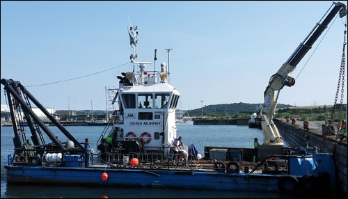
The Port of Cork—reputed to be one of the world’s largest ports, geographically—services the south of Ireland. To keep its waters clear of obstructions created by silt that could impede the passage of large vessels, it is necessary to regularly clear the seafloor of sediment. The port sends its MV Denis Murphy utility vessel into the harbor daily to conduct a variety of maintenance services, including inspecting buoys and plowing the seafloor.

Seafloor plowing—an alternative to standard dredging—consists of lowering a large, multi-ton iron implement into the water and dragging it along the sea floor, explains Arnaud Disant, SEA-Tech’s founder. This loosens silt, he says, which is then washed away by the outgoing tide, thereby ensuring the necessary clearance for vessels.
Identifying the specific locations where the actual plowing is performed, as well as when this occurs, can be difficult. Sometimes, only the vessel’s skipper knows exactly where plowing has taken place. Without an automated system to manage the boat’s location, details regarding the vessel’s real-time location, as well as what work has been done on a particular day, are known only to vessel crews. While the Denis Murphy‘s GPS data is stored on its ship plotter (an instrument used to plot straight lines and angles on a chart, thus indicting a vessel’s location) with the longitude and latitude path overlaid on the charts, this information is stored only on the vessel. What’s more, the GPS system has no way of knowing where the plow has been lowered into or raised from the water.
This makes it difficult for plowing operations managers to know not only where the Denis Murphy is plowing on any given day, but where it has recently been, and thus when it may be at the wrong location. “The innovative nature of what we’re doing is bringing that activity to the office,” says Tom Rossiter, the head of Succorfish’s marine division.
On behalf of the port, SEA-Tech tested the Succorfish system this past summer aboard the Denis Murphy. Next month, SEA-Tech plans to launch the pilot that will enable the port to collect data from the system necessary to track vessel-plowing operations.
For the summertime test, SEA-Tech installed the SC2 device, a smartphone-sized piece of equipment that mounts atop the Denis Murphy‘s bridge. The SC2 has a built-in GPS unit and can transmit location data via a GPRS or GSM cellular connection. If the vessel travels beyond a cellular connection, the SC2 device data can store the information until coming back within range of a cellular tower, or transmit the data via Iridium satellite transmission.
Once the Succorfish system was put in place this summer, however, the port found that the location data was not all it required. Even though management knew the vessel’s location each day, it did not know precisely where plowing had taken place. Sometimes, for example, the ship might report to a specific area to provide maintenance support unrelated to plowing, and management could not then determine whether or not plowing was performed at that site.
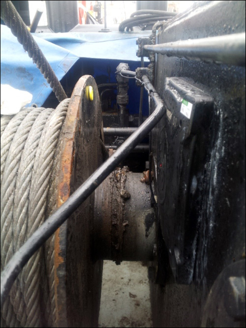
Succorfish and SEA-Tech determined that RFID was the best solution to that problem. The companies installed three passive high-frequency (HF) 13.56 MHz RFID tags to the winch’s drum, on which a cable was spooled and rolled either up or down as the winch raised or lowered the plow from the vessel. The tags are mounted at 120 degrees from each other, in a circle around the winch drum.
The team also mounted an RFID reader near the winch, with a cabled connection between it and the SC2 cellular and GPS device. Rossiter declines to specify the make and model of the tag or reader used, but says they were off-the-shelf products tested for their read accuracy in the highly metallic environment.
As the winch begins to turn, the tags circle past the reader, which has a read range of approximately 100 millimeters (3.9 inches). Each tag’s unique ID is then read repeatedly in succession as the wheel continues to turn. The interrogator captures the tags’ ID numbers and begins forwarding that data to the SC2 unit—which, in turn, forwards the read data to the port’s database, where Succorfish software resides. The software pairs the read data with the GPS-based location data, and updates the electronic records related to the Denis Murphy, in order to indicate where and when the plow was dropped in the water. The reader again interrogates the tag when the winch is used a second time to raise the plow from underwater. In this way, the software can determine when plowing has begun and when it has finished, as well as exactly where that occurred.

The collected data will then be stored in the software, and management can use that information to identify which areas in the harbor will require repeated plowing, and when.
Once the trial of the RFID system begins next month, the Port of Cork intends to continue utilizing the technology throughout the winter plowing season. The solution’s benefits are not likely to be felt right away, Disant notes. The archived data from the plowing operations this winter season, he says, will be useful during future seasons as a plowing schedule is developed.
Succorfish also offers the SC2 technology to Welsh scallop fishermen, to enable them to report to the Welsh government where they have been fishing. RFID technology is not being used for that application. Rossiter says he sees use cases for RFID functionality with the SC2 system, beyond simply identifying when plowing takes place. For instance, he says, other items on the vessel could be tagged, such as nets, and fishermen or vessel crews could wear RFID badges to help management understand who was onboard on any given day.