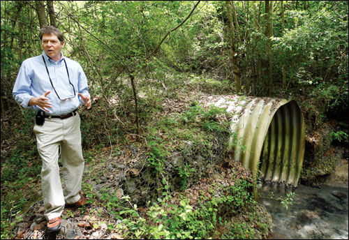
Many countries are placing growing demands on their rivers, using them to generate power, for industrial cooling and more, impacting humans and wildlife. A unique project at South Carolina’s Clemson University, dubbed the Intelligent River, aims to automate the collection of data, to enable better management of this critical natural resource. The research team plans to put wireless sensors in and around the 312-mile Savannah River, from the headwaters in North Carolina to the port in Savannah, Georgia.
“It started in 2007 with a group of faculty who came together to discuss the complex issues of managing water resources,” says Gene Eidson, director of Clemson’s Institute of Applied Ecology. “How do you manage a river? What issues have to be addressed from an ecosystems standpoint? We needed a better strategy if we were going to stretch water resources to meet human needs and the needs of animals and plants in and around the river, and for that, we needed better data.”

Eidson and other ecologists have been using sensors to monitor rivers for years, but these require scientists to visit the sites and download the data. The data can be outdated, and when a sensor is damaged or drifts out of position, data can be lost or corrupted. “You can’t manage a river using data that’s weeks to months old, because the river is constantly changing,” Eidson says. “We needed real-time data acquisition on a large, landscape scale. So, we’re creating the world’s first automated river.”
To achieve such an ambitious goal, Eidson knew he’d need help. He held a symposium on campus of faculty, government officials and others interested in the health of the Savannah River, which runs through the Clemson campus. Then, he put together a team that includes hardware developers, software engineers, river ecologists, visual effects scientists, forestry and natural resource scientists, information technologists and applied economists.
Jason Hallstrom, an associate professor in the Clemson School of Computing and an IDEaS professor, directs technology development for the Intelligent River. Hallstrom had been working with wireless sensors, sometimes called motes, which form mesh networks (see Product Developments on page 29). The technology was a good fit for a project that requires deployment of many sensors across a large area in a highly efficient, low-cost network that could feed data on a real-time basis.
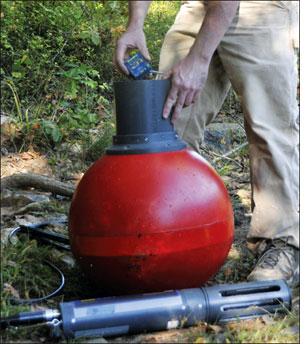
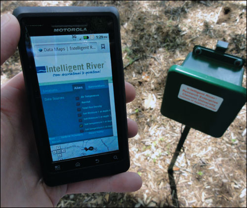
But commercially available motes wouldn’t work in this context. Most use ZigBee, which works well in situations in which sensors are clustered closely together, but not in which they are spread far apart. So Hallstrom and his team designed wireless devices—dubbed MoteStacks—that have standard interfaces. They can accommodate many types of sensors, and researchers can plug in a variety of circuit boards, depending on whether they need to use ZigBee, Wi-Fi (good in urban areas), cellular or satellite communications to send data back to Clemson’s high-performance computing system. Other team members developed middleware, a data repository and visualization software to enable users to tap into the data in real time.
The Clemson researchers have tested MoteStacks in buoys anchored to the river bottom. The MoteStacks are linked to commercially available Data Sondes equipped with sensors that monitor water temperature, flow rate, turbidity, oxygen levels and presence of pollutants.
The researchers just received additional funding and are upgrading all system components. They plan to begin deploying the system in approximately a year. The goal is to be able to alert a factory if discharge is affecting the river, so it can close a valve and limit damage, or react to pollution flowing into the river from urban catch basins.
“We are focused on monitoring everything that would affect the river, including the surrounding watershed, urban sites, farmland, forest,” Eidson says. “We’re putting instruments on the farm, so that the farm is operated through the Intelligent River platform. In the forest, we are sensing data from individual trees, and we’re putting sensors in the floodplains, so we can know when water overflows into riparian wetlands and the estuary. We plan to cover 10,000 square miles, which is the entire river basin.”
Eidson expects the project will save money now spent on manually monitoring the river, and the data collected will be more accurate and timely. The system could prove invaluable for municipalities that want to monitor wastewater discharges and reservoirs, commercial farms that want to monitor sunlight, soil moisture and other environmental conditions, commercial fisheries and other businesses. The project leaders have been exploring models for commercializing the system.
“What we are doing in the Savannah River basin will serve as a model for how we monitor and manage our natural resources,” Hallstrom says. “It will be groundbreaking in terms of the amount and quality of data we are collecting. This information will have a profound effect on how natural resources are managed across the world.”