Jeju (Cheju), a 706-square-mile island located approximately 60 miles off the southwestern tip of Korea, has long been a place known for tourism and for extreme weather. Because of the storms from the south that that stream onto the mainland, Jeju is the primary source of data that the Korean Meteorological Administration (KMA) uses to make many of its predictions regarding weather changes.
For typhoons and monsoons, as well as wind and rain storms, the agency tracks conditions on Jeju closely. In the past, it has done so using wired temperature and wind sensors, in combination with modems and cellular radios. This method has had several shortcomings, however, due to the difficulty of running wires to some of the more remote areas of the island—where wind speeds and temperatures are measured—and the limited bandwidth for transmitting data.

Now, KT Corp., serving as systems integrator, is in the process of installing approximately 300 Firetide wireless sensor nodes throughout the entire island, including its coastal and mountainous regions, to transmit sensor data and video onto a network that can be accessed in real time by the KMA, in order to create what it calls the Automatic Weather System (AWS).
With the Jeju deployment, says Ksenia Coffman, Firetide’s marketing communications manager, the wireless nodes include weather sensors that can detect air temperature, pressure, humidity, wind direction and speed, precipitation, snowfall, visibility, cloud cover, ground temperature and underground temperature. By tracking the weather system on Jeju, South Korea hopes to improve its severe weather predictions and reduce property damage and loss of life through better preparation.
Firetide’s sensor nodes comply with the IEEE 802.15.4 standard for low-power wireless personal area networks (WPAN), forming a mesh network that transmits data for use by the Surface Weather Observation operations of the Jeju Regional Meteorological Administration (JRMA), a branch of the KMA.
The Korean Meteorological Administration had previously installed a network of 600 wired sensors nodes around the island for the AWS that fed information to the KMA. The network has geographic challenges, however, because the sensors must be installed where communication cables can not be utilized. This has led to high installation and maintenance costs and network reliability problems, as well as the expense of using modem connections to transmit data. In addition, the communication line transfers data at only 2400 bits per second. Such a very slow data rate would not permit the transmission of video, or support the ability to share observation data with other agencies and researchers online in real time—two features the KMA wanted to add to the system.
To solve those problems, KT Corp. offered its Ubiquitous Sensor Network (USN)+Mesh system, which included Firetide wireless sensor nodes. In 2006, KT Corp. carried out a trial of the system, according to Hyung-Keun Ryu, a senior researcher with the USN research department at the KT Future Technology Laboratory. In that year, the company installed several sensors using a wireless mesh network in the northeastern area of Jeju Island. A node can communicate with another node or gateway between 2.5 and 10 kilometers (1.6 and 6.2 miles) distant, sending data at a rate of 25 megabits per second.
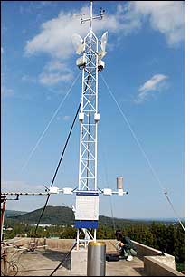
In 2007, during the second phase of the project, KT extended the trial observation network to the southern area of Jeju Island. Today, the company is in the process of installing sensor nodes throughout the island, on towers and poles measuring 12 to 13 meters (39 to 43 feet) in height, while KMA phases out the existing wired-sensor system.
The island’s existing surface meteorological observation technology feeds data to four manned stations, with 19 AWS unmanned stations operating to monitor serious weather. “The plan is to connect all of the 19 stations via the USN network using Firetide hardware,” Ryu says. “This is still in process, with some stations already on Firetide, while the remainder will be connected in the future.”
With the new system, each sensor node transmits its unique ID number, along with sensor data, to adjacent nodes at either 2.4 or 5 GHz, until that information reaches one of the 10 sensor gateways at the island’s manned and unmanned stations. The gateways then send the data, via a cabled Ethernet connection, to a server where it is translated by KT Corp.’s software and forwarded to an aggregation point, or “head node,” located at the JRMA building on the island. At that site, JRMA employs its proprietary software to analyze the data, and can forward it to KMA’s internal ERP system so it can be shared with other KMA offices or agencies.
“All the observation data are stored on a database in Jeju KMA,” Ryu says.
Because nodes support both radio frequency bands, Ryu explains, KT was able to set up a system that could accommodate varying terrains and local regulations regarding the maximum transmit power of wireless devices. The 5 GHz transmission provides greater distance transmission, Coffman says, while 2.4 GHz provides improved penetration. The distance of transmission, according to Coffman, varies according to the terrain, line of site and frequency being used.
Thus far, KT has installed approximately 30 Firetide wireless mesh nodes, covering about 600 square kilometers of the coastal areas, and plans to expand that number to 300. There will also be 20 gateway units when the deployment is completed. The nodes, and other equipment at the sites, are powered either by the AC power grid installed throughout the island or, in more remote locations, by solar panels. In addition, KT has deployed two webcams, wired to two sensor nodes, to provide digital video images that are transmitted with sensor data to the gateways.
With the wireless system, Ryu says, the KMA will save money since there will be no recurring operating expenses (such as cellular service charges). The system, he notes, has a higher capacity for data transmission, making it possible to carry other applications, such as real-time video streaming to show weather conditions. Thus far, he states, “The USN+Mesh system is working very well.”
The sensor nodes have been installed on poles and towers in coastal regions and on mountaintops throughout the island, and have sustained the weather they are designed to measure. During Typhoon Nari in 2007, Coffman says, one node antenna for transmitting data was broken and had to be replaced. Otherwise, she notes, “There were no other issues with the network. The Firetide mesh nodes are extremely rugged and withstood all the bad weather since installation.”
Jeju has a subtropical climate similar to that of the Hawaiian Islands. Between July and September, however, typhoons can cause damage and loss of life. Typhoon Nari killed 12 people and caused massive damage on the island. Since typhoons often come from the south, Jeju also serves as an early warning outpost for southern Korea.