A team of researchers is employing wireless sensors to gain insight into the virtually unknown world of European eel migration. By tracking the animals’ course during their annual travels from Europe to the Sargasso Sea (in the middle of the North Atlantic), scientists at the National Institute of Aquatic Resources, at the Technical University of Denmark, hope to understand the conditions of the waterway in which the eels travel, and thereby fathom why their numbers are dwindling so dramatically.
The tests are part of a larger scientific research project known as Eeliad, focused on gaining a better understanding of European eels, in order to help conserve their numbers. The project includes tracking the animals at sea, as well as research and monitoring projects in freshwater and brackish water, to develop an understanding of the fish’s life cycle.


The Danish scientists had speculated that eels travel approximately 3,000 miles to the Sargasso Sea by spring, after leaving the European coast in the fall. No migrating eels have ever been caught in the ocean, however, so there has been no way to know their exact course, or to verify that the Sargasso Sea is even their destination point. To gain some insight into that migration path, the researchers wanted to measure not only where and how far the eels traveled, but also the depth of water in which they swam, and the temperatures to which they were exposed.
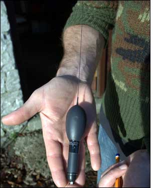
But little technology is available for tracking animals underwater. “We had a very interesting problem there,” says senior researcher Kim Aarestrup. RF or satellite signals would not pass through saltwater, he says, so the sensor and transmitting devices would need to come to the surface to be read. Eels, however, can travel at a depth of thousands of meters under water, and don’t surface at all while migrating. In fall 2006, the researchers decided to try the battery-powered X-tag pop-off satellite tag (PSAT), manufactured by Maryland animal-tracking products firm Microwave Telemetry. The X-tag measures about 4 inches in length and attaches to an eel’s back.
Researchers chose 22 of the largest individuals from a pool of approximately 100,000 eels, which were caught in Ireland by commercial fishermen during the animals’ downstream freshwater migration. The eels chosen weighed about 5 pounds (a typical eel weighs about 1 pound), in order to ensure they would be strong enough to carry the sensors. Scientists attached a tag to each eel by inserting metal wires through the skin on the animal’s upper back—in front of the dorsal fin—and placing protective pads around them, then attaching the transponders to these pads. The eels were then released.
Sensors on the tag collect depth, temperature and light measurements every two minutes, and the tag stores that data on its 64 megabytes of flash memory. The tags were programmed to activate a release mechanism from the eels after various time periods at sea—some after a one-month interval, others at two, three or four months. The release mechanism was also programmed to open and release the tag from the eel in the event it descended to 1,250 meters below the water’s surface (greater depths could permanently damage the tag, rendering it inoperable), or after four days of readings at the same depth, which would indicate the tag was no longer attached to a live eel.
Once released from the eel, the tag floats to the water’s surface, where it begins transmitting a 401.65 MHz signal encoded with its unique ID number and sensor data. The signal is picked up by Argos low earth orbiting satellites, launched by NASA and other agencies to support applications devoted to monitoring and protecting the planet’s environment. To calculate a tag’s location, the system measures frequency shifts in a signal received by a satellite passing over a tag—a phenomenon known as the Doppler effect. The Argos system then makes the data available on its global network, accessible to the scientists with a user name and password. It could also send e-mail messages to scientists, indicating a sensor had surfaced.
The results of the study did not provide scientists with an understanding of the eels’ entire migratory process. However, it did enable the animals to be tracked up to 1,300 kilometers (808 miles) from the point of departure. Fourteen of the 22 tags actually transmitted, proving that the fish were following Atlantic drift currents. The eight tags that did not transmit may have been stuck on the bottom of the sea or in the stomach of a predator, or may have failed to transmit.
The eels seemed to travel between 5 and 25 kilometers (3 to 16 miles) per day, Aarestrup says (the distance was calculated by dividing the distance traveled by the days at large). This was considerably less than the 35 kilometers (22 miles) per day required to reach the Sargasso Sea by April. The tags could have created so much drag that they slowed the fish down, he notes. If not, he adds—if the eels just naturally take longer to get there—researchers would have to reconsider their estimation of the distance the animals travel while migrating. “We can’t rule anything out at this point,” he states.
The data also showed that the eels swim at depths of approximately 650 feet at night, descending to about 2,000 feet during the day. The descent to colder waters, the researchers suggest, delays the eels’ sexual maturation until they reach the spawning ground.
Researchers tagged only 22 eels because of the cost of the technology being used, Aarestrup says. The tags cost about $4,000 each. The scientists intend to begin tagging more eels departing from Sweden in fall 2010, but hope to find a smaller, less expensive tag they can use. The team has not yet determined how many tags it will utilize. In the meantime, the researchers are placing non-transmitting pop-off tags on the eels. The non-transmitting versions have sensors that record temperature and depth, but lack a satellite transponder, relying instead on people to find the tags when they wash up on shore, and then mail them back to the researchers. That process is less expensive than employing PSAT tags, and the scientists are still in the process of receiving retrieved tags.