In June 2016, Columbus, Ohio, beat out six other finalist cities, culled from 87 applicants, to win the Smart City Challenge, a U.S. Department of Transportation (DOT) initiative that enticed cities to make significant improvements to their public-transportation systems through its offer to provide the winner with $40 million in DOT funding. The DOT is looking to stoke relationships between cities and technology providers that will improve the safety and efficiency of transit systems—while also ensuring that transit systems remain accessible and easy to use for all commuters, regardless of their age or access to personal technology. In other words, integrating new technology and public transit must go well beyond adding GPS receivers to busses and then pushing arrival times to smartphone apps.
Public transit agencies are starting to test and deploy vehicle-to-infrastructure (V2X) technology, which refers to communications between two vehicles or between a vehicle and infrastructure (such as a short-range radio device attached to a lamppost or traffic light), as well as the use of sensors that monitor the environment around a vehicle and interact with control systems in the vehicle and/or in the cloud.
Transit agencies are leveraging these technologies to support safety- or efficiency-focused applications, such as collision avoidance, optimal routing and fuel-efficient driving. All of those use cases are converging in the use of self-driving shuttles, which could help transit agencies address a vexing problem: the “last mile” gap between transit hubs and popular destinations, such as corporate campuses, government centers, malls or universities. Because routes to these sites tend to be short and predictable, they’re appropriate for autonomous shuttles designed for short, slow trips.

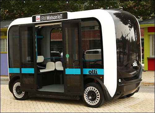
Local Motors, an eight-year-old startup, recently debuted Olli, an autonomous electric vehicle shuttle that holds about a dozen riders and can travel up to 35 miles per hour. The first Ollies have been rolled out this summer for a pilot project in the National Harbor district, along the Potomac River in Washington, D.C. Later this year, transit agencies in Florida’s Miami-Dade County and in Las Vegas will also begin pilot tests to evaluate the use of Ollies for last-mile connectors. (While Columbus’ pitch video for the Smart City Challenge included a short clip of a shuttle that looks like an Olli, Adam Kress, Local Motors’ director of public relationship, says there’s no official plans to test Olli in Columbus at this time.)
A Dutch firm called WEpods is developing a similar shuttle for use in Europe.
To develop Olli, Local Motors partnered with Meridian Autonomous, which uses LiDAR to map the route that a shuttle will drive, and on that map designates building and landmarks that the shuttle’s operating system will use to orient itself while moving through the route. Olli employs IBM Watson‘s cloud-based cognitive-computing capability to collect data from more than 30 sensors embedded in the vehicle. A series of LiDAR sensors, integrated into the vehicle’s body, will send a halt signal to the motor if an obstacle is detected in the vehicle’s path. (Eventually, the U.S. military would like to deploy autonomous vehicles on the battlefield. Before joining Local Motors as its VP of product management, Corey Clothier worked for the U.S. Army Tank Automotive Research, Development and Engineering Center as a consultant on the development of a prototype autonomous shuttle called ARIBIO.)
It will be some time before large public transit busses, which are driven on different routes throughout the course of their lifecycles, become autonomous. But Mobileye, an Israeli firm founded in 1999, is bringing its computer-vision technology, which some automakers use to enable semi-autonomous driving features, to transit agencies.
Mobileye will provide Columbus with its Shield+ driver-assistance safety technology, which uses cameras and computer vision to help bus drivers avoid collisions with cyclists, pedestrians and motorcyclists.
According to the American Public Transportation Association‘s most recent fact book, public transit busses in the United States drove 2.3 billion miles in 2013, and a survey by METRO (a magazine serving the transit and motorcoach sector) determined that a total of 66,142 public transit busses operated in the United States in 2015. Uri Tamir, Mobileye’s director of strategic initiatives, says this represents a huge market for Mobileye’s Shield+ technology, which uses up to four vision sensors (cameras) mounted around the vehicle to collect imagery that is processed in on-board processors and used to alert drivers to the presence of pedestrians or bicycles inside blind spots.
“It’s like the driver’s third eye,” Tamir says—albeit one that only works during daylight hours. While Mobileye uses the same algorithms to process images in the camera module it sells to carmakers, the camera in the module it sells to original equipment manufaturers (OEMs) has enough computational power to “see” potential hazards irrespective of exterior lighting conditions. Not so—yet—with Shield+. However, he says, the next version of the product will be able to work at night. “Our aim is [for Shield+] to see as well as the human eye,” says Dan Galves, Mobileye’s chief communications officer.
Through the Smart City Challenge, Mobileye will install its Shield+ units on 300 of Columbus’ busses (85 percent of the transit agency’s fleet). New York’s MTA also plans to install the technology on 100 of its busses, and Tamir says Mobileye is in talks with dozens of other transit authorities as well.
While Mobileye’s collision-avoidance technology operates on the bus, the data that the Shield+ units collect, all of which is matched to latitude and longitude through an integrated GPS receiver, is later uploaded to the cloud via an integrated SIM card. The transit agencies can then analyze this data in order to identify points on bus routes, such as busy intersections, where the potential for accidents is highest.
“Until now, city officials and planners could only look for infrastructure factors that contribute to a crash once a crash has already happened,” Tamir says. “But imagine a world where you can identify dangerous intersections prior to a crash.”
Mobileye declines to say how much the technology costs transit agencies, but believes that their investment can be offset by reducing the frequency of accidents between busses and other vehicles, cyclists or pedestrians. Fewer accidents, aside from their positive impacts on public safety, would also translate into fewer delays for commuters and the traffic that is blocked or slowed in the wake of a crash. A survey that Mobileye recently commissioned showed that increasing the safety of public transit at dangerous intersections was the third-top issue that respondents wished for from cities, following reduced road congestion and increased public transit availability. (It’s worth noting that a study conducted in 2014 showed that in the United States, taking public transit is actually far safer than driving.)
Reducing accident rates could also lower insurance costs for transit agencies. Recent research from The National Academies of Sciences, Engineering and Medicine found that casualty and liability claims for transit agencies in the United States have increased at an average rate of 2.8 percent per year (for an annual average of $8,069 per bus) between 2002 and 2011. By 2011, insurance claims reached a nationwide annual total of $483 million.