As I write this, the Sands fire has so far consumed 50 square miles near Santa Clarita, Calif., the third-largest city in Los Angeles County. That is an area roughly the size of San Francisco. The fire, feeding on California’s drought-stricken landscape and driven by high winds and temperatures as it snakes through steep canyons, has claimed the life of one man and destroyed at least 18 homes. It is an exceptionally intense blaze, in an era of increasingly intense, destructive (not to mention expensive) wildland fires.
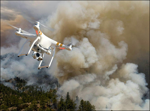
Technology could help the 3,000 firefighters who are battling the Sands blaze—by making their efforts more effective and potentially reducing some of the inherent danger of the work. Unmanned Aerial Vehicles (UAVs), or drones, armed with infrared cameras could help ground crews see through the smoke and understand where the fire is hottest, or how it is behaving in ways that human pilots flying over the flames cannot. Or, they could use the devices to more accurately determine the size and likely path a fire is taking. But, while it has spent years evaluating UAVs in limited real-world tests, the U.S. Forest Service has not put UAVs in its firefighting arsenal in any significant way. This is, in large part, because it is hampered by the Federal Aviation Administration‘s steadfast rule (which applies to both commercial and hobbyist UAV users) that a drone’s pilot must be able to see the device at all times while it is in flight.

Yet, ironically, some UAV hobbyists have, during the past two summers, been making wildland firefighters’ jobs harder and more dangerous. This year alone, according to the Forest Service, hobbyists have flown UAVs in the restricted airspace above wildland fires on more than 15 occasions, and firefighting aircraft pilots have twice had to take evasive actions to avert a collision with drones. And the agency has had to ground its own manned aircraft to remove the possibility of a collision with a drone that could endanger the Forest Service’s pilots. While those planes, which are used to drop water and fire retardant onto the affected sites, were grounded, the flames advanced. One firefighting official likens flying drones near a wildfire to parking a car right in front of a fire station, blocking the exit of fire trucks.
Last month, for the first time, a UAV pilot—a 57-year-old hobbyist from Foresthill, Calif.—was charged with a misdemeanor and arrested for flying his drone above a wildfire. Yet, the agency’s efforts to educate consumers have not totally stopped such infractions. In fact, on Sunday, firefighting flights were grounded in one zone of the Sands fire when a drone was spotted. Then, on Monday, the U.S. Department of Interior (DOI) released news that is probably making Forest Service pilots feel some relief. Working with UAV industry partners, the government has activated a warning system that “provides real-time alerts and geofencing alarms to prevent drone pilots from interfering with firefighting operations,” according to a DOI press release.

Here’s how it works: The Forest Service is now broadcasting real-time wildfire location data, through the Interior Department’s Integrated Reporting Wildland-Fire Information (IRWIN) program, to AirMap and Skyward Industries, two firms that provide mapping and navigational services for unmanned aircraft control systems. (It’s important that this data be updated in real time, because during the peak wildfire season, there might be 300 or more fires on any given day, but many are small and quickly extinguished so the flight restrictions are short-lived.)
While AirMap and Skyward now have access to the IRWIN data feed, only one drone manufacturer—DJI, which manufactured the majority of consumer drones sold in the United States to date—is integrating the wildfire location data so far. It does this through an integration with AirMap’s software, into its controller application, which the pilot uses via a laptop, tablet or smartphone.
The DJI control app, utilizing the IRWIN data, automatically creates a geofence around the restricted area near a wildfire and prevents UAV pilots from flying into it. (DJI also uses this geofence to prevent pilots from flying into permanently restricted areas around prisons, airports and nuclear facilities.) Authorized users, such as fire-management personnel who are in communication with and coordinate their flights with the agency’s pilots, will be able to override the restriction. But as noted above, the Forest Service does not seem to be employing drones for wildland fire missions in any significant numbers.
Hopefully, other drone manufacturers will come on board soon, and all consumer drones will eventually be prevented from flying into restricted airspace around wildfires. There’s no word yet regarding whether Skyward is partnering with any hardware providers to enable the same type of geofencing functionality in drones from other brands. GoPro is supposed to release a drone for the consumer market later this year and, given the popularity of its other products, it’s possible that many consumers who want a drone are waiting for GoPro’s product to hit the market before investing in the technology. I’d be surprised, and disappointed, if the GoPro drone didn’t support the wildfire geofencing function as soon as it becomes available.
I don’t think hobbyists who fly drones into restricted airspace around wildfires do so out of malice—in fact, I’d bet some of them have simply been trying to get an aerial view of a wildfire marching toward their homes. And back in 2014 and 2015, when drones were brand-new toys, some pilots might not have realized that they were breaking any laws by flying them near wildfires.
But the time has come (in fact, it’s past due) for individuals who pilot drones to take more responsibility for their actions. The time has also come (and is also past due) for the government to work in tandem with UAV technology providers to address the problems that drone pilots cause when they fly their craft near wildland fires. Because all indications show that such fires are only going to become more common and more deadly in the future—and that drones will as well.
Mary Catherine O’Connor is the editor of IoT Journal and a former staff reporter for RFID Journal. She also writes about technology, as it relates to business and the environment, for a range of consumer magazines and newspapers.