NY Waterway is a private company that provides transportation services to the New York City area, operating ferries on the Hudson and East Rivers. As such, it plays an important role in the region’s transportation network, especially because its ferries sometimes operate even when other systems fail. For example, following Superstorm Sandy in 2012, NY Waterway was the only mode of public transportation that did not suffer service interruptions. The ferries can also play a special role in the event of an emergency—in 2009, for instance, a NY Waterway ferry was the first on the scene to respond to the emergency landing of US Airways’ Flight 1549.
Today, Hitachi Data Systems (HDS), a wholly owned subsidiary of Japanese technology company Hitachi, announced that NY Waterway is using networking tools and a communication platform that HDS developed to support smart-city applications, as part of a program to improve its video capture, wireless communications and safety systems on its fleet.
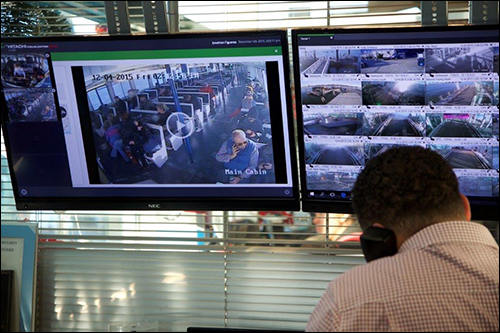
HDS worked with systems integrator AAS Technologies, which upgraded NY Waterway’s video surveillance system aboard its ships, installing 350 new video cameras linked via Internet Protocol to gateways provided by HDS. The gateways, which integrate cellular, Wi-Fi and Voice over Internet Protocol networks, are part of the Hitachi Visualization Suite and support data streaming, video capture and monitoring, with transmission rates of up to 100 megabits per second on ferries that travel at speeds up to 35 knots (40.3 miles per hour).

The suite uses Hitachi’s visualization software to aggregate and integrate data collected through the gateways, as well as from other networks—which, in this case, includes the automatic identification system (AIS) that NY Waterway employs to track the locations of its ferries—to provide a single, browser-based interface. NY Waterway utilizes the Hitachi Visualization Suite to monitor and communicate with passengers and employees on vessels, both in terminals and as they move across the water.
The AIS monitors each boat’s location, direction and speed. “We layer on that a map with other information, such as weather, radar showing the location of smaller vessels that are not transmitting location over the AIS, and the video feeds from the boats,” explains Mark Jules, Hitachi Data Systems’ VP of public safety and visualization solutions. The visualization suite allows NY Waterway’s fleet managers to click on any ferry icon and pull up data related to its location or speed, or a video stream from that boat.
In the event of an emergency, the system enables NY Waterway to issue alerts to passengers, via digital screens mounted on the ferries and in terminals, and through a public announcement system. But because the visualization software is cloud-based and accessible via an Internet-connected computer, the company—which operates its own private security force—can also issue safety alerts to state and local agencies and grant them access to the platform.
Jules says that NY Waterway could also incorporate facial-recognition software into its video-capture system and integrate that data into the visualization suite as well, using the software to monitor passengers as part of its safety system. In addition, it could integrate sensors for monitoring engine health, so if, say, an engine began to overheat, the platform could trigger alerts to ferry mechanics.
NY Waterway does not currently push notifications to passengers who use its mobile app, but if the app is upgraded to allow push notifications, it could be added to the HDS platform, which would enable the company to issue alerts or notices directly to passengers’ phones. In the event of an emergency or service shutdown, this could provide its customers with more time to find alternative means of transportation before they head to a ferry terminal.