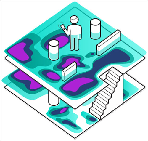
Finnish technology company IndoorAtlas sells location-tracking software that it says can leverage Earth’s magnetic field to map the unique magnetic signature inside modern steel-structured buildings, and then determine the locations of smartphones moving within those spaces, to an accuracy of 1 to 2 meters (3.3 to 6.6 feet). Its technology, the company reports, enables businesses to communicate with consumers via their smartphones, while requiring less infrastructure and providing greater location granularity than beacon- or Wi-Fi-based alternatives.
Last week, IndoorAtlas announced that it has signed an agreement with Yahoo Japan through which Yahoo Japan will employ IndoorAtlas’ geomagnetic position technology to map indoor spaces and provide indoor location-based services in Japan. This follows six months during which Yahoo Japan tested the technology in Tokyo.
Daniel Patton, IndoorAtlas’ chief commercial officer, says the agreement could mark significant growth for its footprint in Asia, since Tokyo has the fourth largest smartphone market in the world and its metropolitan area is home to 38 million residents. During its tests, Yahoo Japan, a joint venture between Chinese telecommunications firm Softbank and tech company Yahoo, mapped indoor spaces in Tokyo, such as subway tunnels—which, Patton notes, contain many restaurants and retail shops.

To make a map, he says, the customer (in this case Yahoo Japan, or a third party it hires) must have an individual walk through the building with a mobile device running the company’s mapping software. The software uses the device’s magnetometer (compass) to detect each part of the building’s unique magnetic signature, Patton explains, which is generated by the disturbances the steel infrastructure causes to the Earth’s magnetic field. It then transmits this data, along with the building’s floor plan, to IndoorAtlas’s cloud-based server, which creates a geomagnetic positioning map.
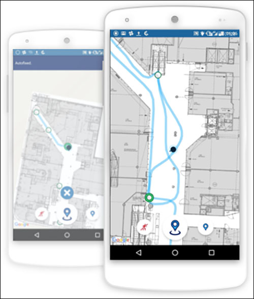
When a smartphone user in an indoor space that has been mapped uses a mobile search or map application (such as Yahoo Japan’s) that has integrated Indoor Atlas’s software development kit (SDK), the IndoorAtlas server is queried and the provider receives that user’s location. Based on that information, the mobile app’s provider may serve an advertisement or special offer to the user, based on agreements that the provider has with nearby businesses.
Consumers can also download retailer apps that leverage IndoorAtlas’ geomagnetic positioning data and will direct them to a specific product within the store, or a real estate management company could offer an app that helps shoppers navigate a mall. At the Chhatrapati Shivaji International Airport, located in Mumbai, India, the Mumbai T2 app uses IndoorAtlas software to direct travelers through the airport’s Terminal 2, Patton says.
IndoorAtlas’s first major customer, Chinese language Internet search provider Baidu, invested $10 million in the company in 2014. Baidu integrated IndoorAtlas’s SDK into its mobile search and mobile mapping applications (of which more than 300 million Chinese consumers are active users). This enables Baidu to serve ads or special offers to consumers whose phones run either the search app or mapping app, based on their location within a building—assuming that building has already been mapped.
IndoorAtlas says its partners have mapped 15,000 buildings to date throughout more than 100 countries, and that there are 200,000 monthly active users. However, it declined to reveal to IOT Journal how those users are geographically distributed.
Janne Haverinen, who worked as a professor and senior research fellow in the Computer Science and Engineering Laboratory of Finland’s University of Oulu, and who now serves as the firm’s CEO, founded IndoorAtlas in 2012. Haverinen assembled a group of fellow academics that brought their backgrounds in computer science, signal processing, pattern recognition and robotics to the task of devising the means by which IndoorAtlas can scan and map indoor spaces.
IndoorAtlas sells its geomagnetic positioning software and location-tracking services as a platform-as-a-service, through partnerships with mobile application providers. It supports both Android and iOS mobile operating systems. IndoorAtlas charges its customers according to a tiered pricing plan, based on the number of its monthly active users.
While IndoorAtlas negates the need to install and maintain networks of Bluetooth beacons, it does require the organization leveraging the technology to map the indoor spaces it wants to monitor.