IBM, as part of its Smarter Planet technology initiative, is teaming up with parking technology firm Streetline to provide an RFID-based parking-management system that would allow cities to better track parking availability on streets and within garages, while also enabling drivers to learn where parking spaces are available. Streetline’s ParkSight solution employs magnetic sensors to detect a vehicle’s presence in a parking space, while IBM, says Vinodh Swaminathan, the company’s director of intelligent transportation systems, provides a layer of intelligence with its own software platform—known as Cognos—that can manage historical data from the Streetline system regarding parking, and provide reports about parking behavior at different locations.
Smarter Planet, which includes a Smarter Cities initiative directed specifically at urban areas, is IBM’s program to use sensors in a variety of settings, in order to provide data that can help improve services and infrastructure in specific cities and worldwide. This includes smart electric grids and water-management systems, greener buildings, and traffic-congestion solutions. To help improve traffic flow, IBM has provided solutions to Stockholm and other cities, based on such sensor technologies as cameras and lasers. “We have a pretty robust business around sensor technologies,” Swaminathan explains. Now, he says, with the Streetline partnership, IBM will add parking management to its offerings that utilize RFID technology. “Parking is a wonderful extension of Smarter Cities,” he states.

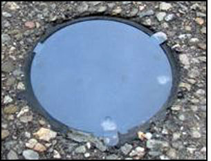
IBM recently completed a survey in which it found that more than 30 percent of traffic congestion within cities is caused by drivers circling in an effort to locate parking spaces. The pressure from inefficient parking systems is felt not only by drivers, but also by merchants relying on their customers’ ability to find parking spaces near their business. “For us, in partnerships with companies like Streetline, we have a very exciting offering to provide a way [for cities] to significantly enhance services,” Swaminathan says.Streetline has already installed ParkSight throughout numerous cities worldwide, including San Francisco (see SF Uses Wireless Sensors to Help Manage Parking). The solution includes 2.4 GHz battery-powered wireless sensors that form a mesh network using the IEEE 802.15.4 air-interface protocol. The sensors containing Streetline’s own transponders are attached to or embedded into a parking space’s pavement, and their signals are received by repeaters (readers) mounted on light poles or on other permanent structures within the area. Each sensor can detect whether or not a vehicle is parked over it, and transmit that information to the repeater, which then forwards the data to a gateway device with a Dust Networks network interface card (NIC), through which the information is then forwarded to an Internet connection. In that way, the sensor data is sent to a Streetline-hosted server.
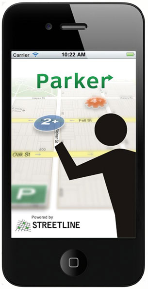
For a typical parking deployment, Streetline installs approximately 120 to 200 sensors, along with 15 to 20 repeaters and a single gateway. Each sensor determines whether a vehicle is parked above it, and the Streetline data thus indicates, in real time, which parking spaces are being used, and which are empty. Over the past 12 months, says Zia Yusuf, Streetline’s CEO, 14 new customers have begun using the technology. Among the most recent customers is the California city of Sausalito, where drivers can use Streetline’s free smartphone application, known as Parker, to learn which parking spaces are available. That function includes a display indicating, for example, that a particular block contains more than four empty spaces, or that it has none, as well as an arrow pointing to locations at which more promising parking prospects can be found within a driver’s vicinity.
Streetline’s ParkSight data can be accessed by a city, allowing management to, for instance, detect where and when a vehicle has exceeded its allotted time in a parking space, thereby enabling city employees to issue tickets more promptly. The same functionality could be utilized by managers of municipal parking garages or lots to detect when a specific space has been occupied for too long, or where vacant spots may be located, in order to better serve incoming drivers.Using IBM’s analysis solution in conjunction with Streetline’s technology, municipal parking managers can also determine whether enforcement officers are productive, where the greatest revenue from fines is being acquired, and the length of time that drivers typically park in particular areas.
Since the Sept. 28 announcement of the Streetline-IBM partnership, Swaminathan says, cities have been calling IBM from around the world requesting details of the arrangement.
With IBM’s solution, the data will continue to reside on Streetline’s server, but with the company’s analytics functionality included. Price and payment plans would vary according to each customer’s individual use case and needs.