As teams of rescue workers moved throughout New Orleans after Hurricane Katrina struck that area in August 2005, they frequently wrote codes on buildings to inform groups arriving behind them of important information, or to help those disoriented by the rubble realize they had already been to a particular site. For instance, the codes revealed whether a building was dangerous, or safe or contained rubble.
Researchers in Germany’s Black Forest region have developed an RFID extension of this coding system. Their RFID-supported urban search-and-rescue concept features robots and humans working together in disaster zones to map an affected area and transmit information to a command center.

“It works like ants do,” says Alexander Kleiner, a researcher at Albert-Ludwigs-Universität Freiburg in Breisgau, who wrote a thesis about RFID-based mapping for search and rescue with robots and humans. “Ants leave a trace that the others can smell to say that they have already scouted a certain area.” The goal of the project, which is funded by the university and the German Research Foundation (DFG), is to create a system for efficiently mapping disaster areas using people and robots, thus speeding the rescue process and saving lives.
For instance, rescue workers and robots can jointly apply RFID tags to buildings that have already been checked following a disaster, and write key information to the tags so other teams need only read them with PDAs to discern a particular building’s status, or to obtain a recommendation of where to proceed next. What’s more, as various teams and robots approach via differing paths and read the tags, data can be associated to calculate the tags’ location, and to generate a consistent map for use by the central command post. This is particularly useful, for example, if nearby building structures made of reinforced concrete obstruct GPS satellite signals from being read.
Last year, Kleiner and his colleagues tested the system with robots and humans on the university campus using passive RFID tags. And in early 2008, the researchers conducted a test with robots only, using active tags.
Passive RFID Mapping Experiments
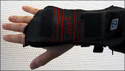
The first experiment, utilizing Tagsys‘ Ario passive 13.56 MHz RFID tags and Medio S002 interrogators, was carried out by a six-person team in Freiburg in April 2007. Each individual was equipped with an electronic compass, an electronic pedometer and a glove, developed by TZI Bremen, with a built-in wireless RFID interrogator.
The devices were all connected to a small, notebook-style PDA carried by each team member. During this experiment, the humans explored 9 kilometers (5.6 miles) of an urban area consisting mainly of residential buildings with up to six floors. They used the basic navigational technique of dead reckoning—estimating current position based on a previously determined fix, then estimating subsequent positions base on speed, elapsed time and course traveled—to calculate their positions with an error of about 70 meters (230 feet). By reading the 20 RFID tags embedded in self-adhesive labels they had placed on buildings at intersections, then combining this information with that collected via dead reckoning, the team was able to calculate their positions with an error of 10 meters (33 feet). However, Kleiner says, it was difficult to produce a high-quality map because of the large error in the estimates, since people climbed stairs, walked up slopes and ran.
“If you use passive RFID, you can only collect information by getting very close to the tag,” Kleiner notes. “Hence, passive tags only help rescue workers know if they have already been to a certain place. Dead reckoning gives an initial guess of the track. However, its error continuously grows the longer you travel. By using RFID to recognize when a pedestrian has walked a ‘loop,’ the system can map a whole track. Mathematically speaking, second readings of RFID tags are ‘hard constraints.’ The algorithm rearranges the track so that all re-visited places fit.” The procedure, he says, is known as Simultaneous Location and Mapping (SLAM), and consists of combining associated RFID data with location estimates.
In addition, participants also carried GPS devices, with location data collected via GPS used to verify the maps.
In a separate experiment, conducted in August 2007, a human and a robot jointly created a map by employing RFID to improve dead-reckoning estimates. The robot was equipped with a compass, a wheel-based odometer and an RFID reader with its antenna mounted parallel to the ground so it could read tags placed in the ground as it rode over them. Both the robot and the human explored an area approximately 900 square meters (2,953 square feet), reading 10 passive RFID tags previously embedded in the ground. They were able to improve their dead-reckoning estimates from an error of 150 meters (492 feet) for the human and 50 meters (164 feet) for the robot, down to 5 meters (16 feet) for both. Separately, the researchers also tested a device in a basement for automatically distributing RFID tags.
Using Active RFID Sensors
The University of Freiburg’s department of microsystems engineering developed wireless sensor nodes that meet the ZigBee specification for an experiment with active RFID. The sensors measure air pressure, temperature and antenna orientation. “The sensor node houses a two-axis accelerometer that measures gravity in order to determine the orientation of the antenna,” Kleiner says. “Thanks to this information, the sensor detects when the antenna is not appropriately orientated—i.e., if it has fallen over.”
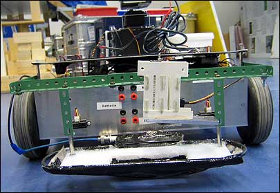
During the experiment, nine active RFID tags with sensors were mounted outdoors on traffic pylons, with the tag’s orientation fixed. Four robots navigated the area, one after another, reading tags and leaving behind information for other robots. All of this data was then collected and processed to create a map.

By using the information obtained from the other robots, Kleiner says, single robots were able to improve their maps compared with those based on their own observations, which had a margin of error of 2 meters (6.6 feet). “You can imagine this as follows: The first robot drives around and computes a map from dead reckoning and RFID observations,” he explains. “This map is better than the one from dead reckoning alone. The resulting map is stored on each nearby RFID tag. Then, the second robot goes through the area and does the same as the first one. However, it also reads the information from the previous robot and creates an even more accurate map.”
The robots detected the active RFID signals 30 meters (98 feet) from tags, and created a map with an error of 1 meter (3.3 feet). “Here the accuracy depends mainly on the accuracy of estimating the distance to RFID tags, based on the signal strength,” Kleiner says.
“We learned from our experiments, the environment and the arrangement of the tags significantly influence signal path attenuation. These parameters have to be predicted for reliable distance estimation from signal strength,” Kleiner says. “To apply the method in indoor environments would be more difficult because signals can be reflected by objects and walls, leading to signal propagations via different paths, known as the ‘multi- path propagation’ problem.” It is possible, he notes, to use the RFID system indoors if the 3-D model is known beforehand. Robots can learn specific models for the purpose of locating people inside a building.
Companies have begun showing an interest in the idea, Kleiner says, and he hopes to obtain more funding through the European Union, since his system of mapping can also be employed for such security applications as monitoring nuclear plants with robot teams.
“I’m sure that anyone researching SLAM methods will see that RFID is the most promising solution from a practical point of view,” he says, “since the inherent assumptions for most SLAM methods are not present in a disaster situation. Cameras don’t help rescue teams because they can’t see through smoke. GPS fails completely when satellite signals are blocked by structures made of reinforced concrete. And 3-D laser measurement techniques are still too expensive.”