Orbit One, a long-time provider of satellite solutions for emergency and disaster response, has introduced a new service leveraging a proprietary active RFID tag that communicates with low earth orbit (LEO) satellites. The service, known as Global-RFID, or G-RFID, is designed to give companies in-transit visibility and tracking of cargo containers, generators and other high-value assets.
“Our technology was originally developed for emergency response and disaster response situations,” says Gary Naden, CTO for Orbit One, a division of Numerex, an Atlanta-based provider of fixed and mobile machine-to-machine wireless solutions and network services. “We’ve taken that technology and put it through, from scratch, a new design process.”
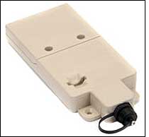

G-RFID’s active tag, the SX1, includes a field-replaceable lithium battery, an internal motion sensor and an integrated GPS chipset, in a rugged plastic case measuring 7.25 by 3.25 inches and weighing 13 ounces. Through a serial USB port, the SX1 can accommodate up to eight external sensors, such as those measuring temperature or light exposure, that can be used to alert companies to environmental conditions, or to any tampering their assets might encounter. A sensor might detect when light hits it, for instance, indicating that a container has been opened.
The SX1 can be easily attached to an asset using double-stick tape or other peel-and-stick mounting options, Naden says, and it can also be screwed on or attached with a mounting sled. For the tag to communicate with the satellites, however, it can not be inside an object, such as a cargo container, railcar, building or ship’s hold.
“As with any GPS device, the more sky it can see, the better it can acquire a fix,” Naden explains. “That being said, we do have customers who are making the performance tradeoff to mount the device vertically, such as on the door of a container. The tradeoff is seeing half the sky, which impacts GPS search time and satellite transmit success rate. For those customers, it is better to see the tag on the asset, access it easier when necessary, and have it operating when stacked. This is possible due to the LEO satellite use. If we were shooting at GEO satellites, it would absolutely need to be on the top, in clear view of the sky, to always have line of sight to the stationary satellite.”
Printed on each tag is a bar-code representation of its unique ID number. When a company receives the tag and is ready to affix it to an asset, employees can scan the bar code to populate the company’s database, thus creating a correlation between the asset and the bar code and tag ID number.
The tag is programmed to activate several times per day (it can also be activated to transmit data based on specific events captured via sensors) and send its GPS-determined location information (latitude and longitude) and unique ID number to the nearest LEO satellite. The tag can be quickly turned off using a magnet on top of it, assuming the tag is configured to support the on/off function. “It can also be configured to ignore the magnet,” Naden says, “in which case, one would need to connect to the USB port with a PC or field tool to send a command to disable the device. To change the operational parameters, you must similarly connect to the USB port to effect the change.”
LEO satellites circle the earth at an altitude of about 500 to 1,000 miles, versus an altitude of about 25,000 miles for a geostationary earth orbit (GEO) satellite. There are three commercial LEO constellations, each containing about 30 to 70 satellites. Orbit One is leasing bandwidth from voice and data satellite service provider GlobalStar, which operates a constellation of 50 LEO satellites.
An SX1 tag communicates its information to GlobalStar’s satellite system, which then delivers the data to servers in Orbit One’s Denver and Salt Lake City data centers. Orbit One, Naden explains, opted to have two data centers to create a fail-over option in the event that one was unable to operate. From there, the data can be pushed to a customer’s network, or customers can utilize Orbit One’s optional secure Web portal to access the data.
Available now, the SX1 tag ranges in price from $250 to $350, depending on volume, plus a monthly service fee ranging from $5 to $20 per tag, depending on usage. Each tag comes with a three-year warranty. Orbit One is targeting the U.S. Department of Defense and other organizations and companies with global supply chains, and is developing a temperature sensor to offer its customers. The SX1 tag, through its USB port, can be connected to sensors already available on the market.
“We are working with several companies developing custom sensors and custom OEM applications that integrate the SX1 Engine into the product,” Naden says. “These customers have yet to introduce a product, so it is premature to spill their story.”
Several other companies offer similar active RFID tags and services that work in conjunction with satellites. These include AeroAstro, which markets its LEO-based Sensor Enabled Notification System (SENS) Data Service to companies and organizations that need to track trucks, trailers, containers and other valuable assets (see Low-Cost Satellite Tracking Offered).