McMurdo, a maker of emergency position indicating radio beacons (EPIRBs), personal location beacons (PLBs), search-and-rescue transponders (SARTs) and other search-and-rescue devices, has announced its two latest PLBs designed to further aid in locating individuals during an emergency. This news comes on the heels of a search-and-rescue operation in which a sailor’s life was saved after he activated his McMurdo PBL during a storm off the African coast.
PLBs are pocket-sized active RFID transponders that boaters, pilots, hikers and others can utilize in the event that they become lost or incapacitated. Although there are a variety of PLBs on the market, Cospas-Sarsat—an international search-and-rescue organization that operates a satellite system to detect and locate the signals of distress beacons—supports only those operating at 406 MHz or 121.5 MHz (processing of 121.5 MHz beacons will terminate on Feb. 1, 2009).

When activated, typically by a user pressing a button on the unit, a PLB transmits a unique ID number. In a registration document owned and managed by Cospas-Sarsat, each ID number is correlated to information about the PLB’s owner. Typically, a PLB’s location is determined by the three nearest satellites that take a position fix using what’s known as the Doppler location process, according to Jeremy Harrison, sales and marketing director of McMurdo, a subsidiary of RFID and GPS products manufacturer Digital Angel Corp., based in St. Paul, Minn.
“This will take, typically, 45 minutes from the time a PLB is activated,” Harrison says, “and will give a position accuracy of a three-nautical-mile radius [28 square miles].” The satellite closest to the determined location of the PLB then relays information to the nearest base station, more than 20 of which are scattered around the world. The base station reviews the data and, if the alert has not come from a military entity, passes that information along to the governing agency, such as the Maritime & Coastguard Agency (MCA) in the United Kingdom. From there, decisions are made regarding search-and-rescue operations.
The use of PLBs and other types of emergency location transponders is on the rise. According to Cospas-Sarsat, the organization’s alert data assisted in 435 distress incidents in 2005 (24 percent involving PLBs), in which 1,666 persons were rescued. In 2006, the Cospas-Sarsat system provided assistance in 452 search-and-rescue operations (279 triggered by 406 MHz beacons, 173 by 121.5 MHz beacons), rescuing 1,881 persons. Cospas-Sarsat estimates there are more than half a million 406 MHz distress beacons deployed worldwide.
On Jan. 4, Harrison says, a 22-year-old U.K. boat builder named James Barker was sailing off the coast of Africa when he ran into extreme storm conditions that damaged his yacht, causing it to take on water. Barker activated his McMurdo FastFind Plus GPS PLB, and the alert was passed along to the MCA’s branch in Falmouth, U.K., which then contacted officials in Morocco, Portugal and Spain, requesting to ask for their assistance.
The officials transmitted calls for help to shipping vessels, and three commercial ships were able to begin searching the area. Shortly thereafter, an aircraft from the Portuguese Navy found the yacht 74 miles west-northwest of Casablanca. The navy then directed a German commercial vessel, the MV Wappen Von Bayern, to the site, which was able to recover Baker.
PLBs are critical to solo sailors such as Baker, Harrison says. Although boats are often equipped with EPIRBs, which work the same way as PLBs, EPIRBs are more expensive and are normally fixed to a boat. “It is probable [Baker] chose the PLB because it is lower-cost than an EPIRB, and also because he is sailing alone,” Harrison states. “That means it is important to have a location system that it is with you at all times.”
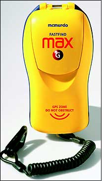
McMurdo’s two latest PLBs include the MAX and the MAX-G, additions to the company’s FastFind line of PLBs. Both can now operate for up to 48 hours once activated (compared with the 24-hour activation life of previous models), thanks to new, lower-current circuitry on the PLBs. They can operate in temperatures of up to -20 degrees Celsius (-4 degrees Fahrenheit). The FastFind MAX G has an integral 12-channel GPS navigation receiver. Both models have passed Cospas-Sarsat technical testing, Harrison says, and are expected to be available the second week of February.