At first blush, it might seem odd that Wuerth ITensis—an IT outsourcing services arm of the Wuerth Group, a €5.9 billion ($6.6 billion) multi-national manufacturer of screws and other fasteners—would design and build an Internet of Things system to help ski school instructors monitor their charges. But consider this: Before joining Wuerth ITensis as the company’s business manager, Claudio Hagmann spent a decade as the chief information officer of the Swiss ski resort Laax.
“We had been looking at new markets,” including the IoT, Hagmann says. “We did some brainstorming, but at the end of the day we decided we should not just talk about IoT and digitization—we should do something. So we all went to Laax as ski guests, and thought about how IoT could be used. I knew that keeping track of students is difficult for ski instructors, because each teacher has eight to 10 kids in each session.”
Indeed, on a foggy day in late March, one child took a wrong turn and ended up skiing down a different valley, which separated him from his group and teacher. It took 60 people three hours to locate him. “Usually, the teacher turns and looks uphill around every two to three turns to check on the group,” Hagmann explains, “but visibility can be cut to 15 meters or less in fog.”

Hagmann and his colleagues quickly got to work last winter to develop a system that could help ski instructors keep better track of their charges. Because the majority of students are only six or seven years old, most do not carry smartphones, so the system could not rely on tracking the GPS location conveyed via phones. Consequently, Wuerth ITensis brought in a partner, IoT network and services provider TalkPool, which suggested using sensors that comply with the LoRa Alliance‘s communications protocol for low-power wide-area networks (LPWAN), a spread-spectrum technology that has a long range of up to 15 kilometers (9.3 miles) in rural areas.
For a short pilot test conducted at Laax during the tail end of the 2015/16 season, Wuerth ITensis created 10 special vests with embedded geolocation tags, supplied by French manufacturer Abeeway, that combine a GPS module and a LoRa radio, and issued these to the students. It installed a single LoRa access point made by Kerlink, which contained a LoRa radio manufactured by Semtech. Instructors involved in the pilot downloaded a ski tracker app to their smartphone.
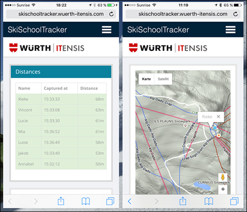
As a student was registered for ski school, he or she was issued a LoRa tag and its corresponding identifier was associated with that child’s registration information. This data was then captured and forwarded to a cloud-based database that Wuerth ITensis maintains and links to its SkiSchoolTracker mobile application.
Out on the slopes, the students’ tags were transmitting their GPS locations to the access point, which forwarded the data to Wuerth ITensis’ web-based application via a cellular backhaul. An instructor could then look at her phone to view a list of all students and their distances from her location at any given time.
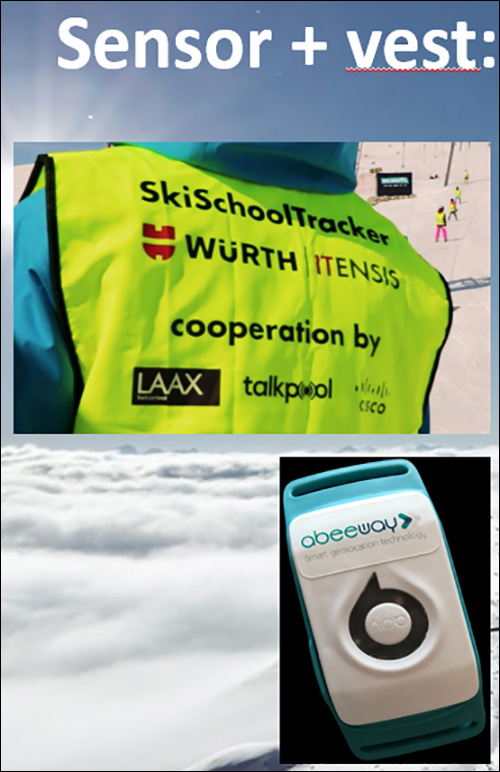
The pilot worked well, the company reports, but the use of GPS to track the students’ locations consumed far too much battery life from the Abeeway tags—in fact, with the GPS position set to transmit once per minute, the battery in each tag only lasted for 8 to 10 hours. “Our goal is [for the battery to last for] one ski season, or 5 months, with one charge,” Hagmann says.
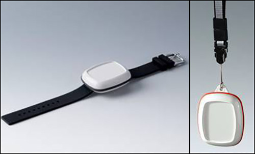
Wuerth ITensis is currently working with TalkPool to develop a LoRa tag, which will likely be in a wristband form factor, that it will issue to students and teachers for the technology’s rollout at Laax this coming winter. Rather than transmitting a GPS location, a tag will transmit only a unique number, linked to the student wearing that tag when he or she enrolls in class, to a network of access points. Each instructor will also carry a LoRa tag.
Hagmann says the plan is to install up to 16 LoRa access points (Wuerth ITensis and Talk Pool have not yet chosen a manufacturer, he notes) across the resort. The access points will be used to determine each student’s location, based on the time of arrival of that child’s tag transmission, provided that at least three gateways receive the transmission and can, therefore, triangulate its location.
The high number of access points should provide adequate coverage across the resort, says Stefan Lindgren, TalkPool’s chief technology officer. “The accuracy [of geolocation using LoRa access points] is dependent on signal propagation condition,” Lindgren explains. For example, if a tag has a clear line of sight to an access point, its distance will be more precisely determined than if structures or geographic features interfere. The rate at which a tag transmits its number will also impact accuracy.
However, Lindgren says, “the benefits from the [LoRa] solution are that the network estimates the position without impacting the device cost, battery consumption” or the data transmission time. “Another benefit is that it works also in environments where GPS signal cannot be received, such as indoors.”
If an instructor does not immediately see a given student during her visual check, her smartphone will show her the distance and direction of the individual for whom she is searching, relative to her own location.
As a fail-safe, the tags will also have a GPS receiver. The tags will not be set to transmit GPS, Hagmann notes, but if a particular student is missing and his tag is not being read by enough access points to perform triangulation, one of the access points reading his tag will be able to turn on the tag’s GPS receiver through an over-the-air command. Once the GPS data is retrieved, the teacher will be able to find the missing student’s location on the map in the SkiSchoolTracker app.