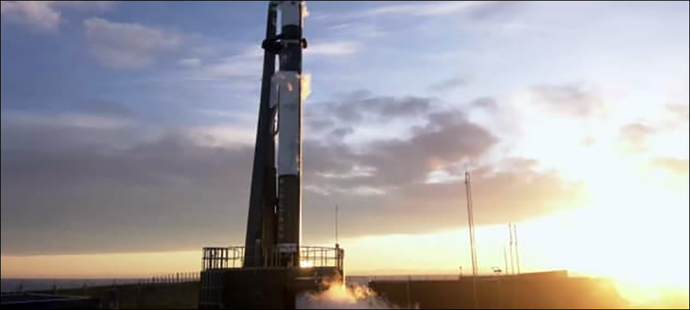
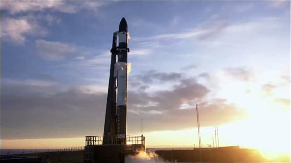
Satellite constellations for Internet of Things (IoT) deployments are growing. The latest plan to extend IoT connectivity beyond standard terrestrial systems involves a series of launches slated to begin during the second quarter of 2023. Rocket Lab plans to launch 25 Kinéis satellites in New Zealand between April and December. The goal is for these small low-orbital satellites to provide real-time geospatial intelligence and global monitoring services.
Kinéis provides satellite-based IoT connectivity. The company was created in 2019 by French space agency Centre National d’Etudes Spatiales (CNES) and IoT technology firm Collecte Localisation Satellites (CLS), says Alexandre Tisserant, Kinéis’s CEO. Among its activities during the past two years, Kinéis has been operating the Argos System, a collaboration that includes CNES, the National Oceanic and Atmospheric Administration (NOAA), the European Organization for the Exploitation of Meteorological Satellites (EUMETSAT) and the Indian Space Research Organization (ISRO). The satellites are being used to collect information about the climate and the environment, as well as to monitor wildlife and fisheries.
Kinéis aims to provide affordable IoT connectivity where traditional technologies, such as cellular, LoRa and Wi-Fi, cannot reach. Currently, only 15 to 20 percent of the world has such terrestrial IoT connectivity, Tisserant says, and that opens an opportunity for satellites. In the past, satellite technologies have been considerably more expensive than alternative solutions, he explains, but Kinéis is attempting to bring that cost down with its low-orbital satellites and transmitting sensors. So far, its technology is being used to track animals in remote areas, as well as fishing boats, and it could monitor containers at sea, smart agriculture, and connectivity and utilities in remote areas.

At present, Kinéis has eight satellites in orbit. The units, which weigh 30 kilograms (66 pounds), fly in low Earth orbit at a distance of 650 kilometers (404 miles). With these eight satellites circling the planet, connectivity is typically available for 15 minutes, followed by a wait period of a few hours before the next satellite comes within range. This rate of connectivity is sufficient for those with a fixed infrastructure, or for monitoring the movements of animals. However, for use cases such as fighting illegal fishing operations, IoT systems require more regular data capture.

Alexandre Tisserant
With 25 nanosatellites in space, Tisserant says, what had originally been one or two hours of waiting for a signal will be reduced to only ten minutes. To enable IoT deployments, the company is building both the satellites and the units in sensor devices that communicate with those satellites. These small devices are designed to send relatively small packets of data, he notes, and they require low-energy supplies at a low price. By offering both the satellites and the sensor units, Tisserant reports, “We are democratizing connectivity.”
Kinéis and Rocket Lab have agreed on a fixed span of dates from April to December 2023 to launch the satellites. Each one is about the size of a large shoebox, and they will all be launched from New Zealand. The company chose Rocket Lab, Tisserant says, because “They are the most reliable micosatellite launcher.” The Kinéis sensor units send packets of information for localization, but they can also transmit pressure, temperature and humidity data. In one application, devices transmit such sensor information from ocean buoys. The data is captured on Kinéis’s server, which can provide a basic location, such as a dot on a map, while the company partners with software providers to obtain more detailed information.
The technology is more expensive than standard terrestrial IoT solutions by a factor of three, Tisserant says. However, the price is expected to drop as more sensors are deployed. The relatively large bandwidth in which transmissions are sent means the density of sensors can be high, he explains. “So that capacity will be growing,” Tisserant states, and the price is expected to drop with that growth. “We’re targeting millions of devices” that will connect to the system. Some of the earliest applications have centered around tracking wildlife, for instance. Kinéis makes a unit that weighs just 3.5 grams (0.1 ounce), which can be built into the collar of an animal as small as a bird.
The satellite IoT system can be deployed to augment existing IoT solutions, Tisserant reports. For example, one company that is already using LoRa technology to track containers could choose to add the satellite-based data when those containers were out to sea. The technology is also being used by governments that are tracking industrial fishing boats to save protected sea life. The data collected by Kinéis’s units on boats can helps users locate fishermen and ensure that specific areas are not being overfished. The sensor units can include a GPS device or use the satellite’s own localization with the Doppler effect. The latter option, he notes, is lower in energy and thus requires a smaller battery and less frequent recharging.
A program led by Kinéis, the North Australian Indigenous Land and Sea Management Alliance, the Commonwealth Scientific and Industrial Research Organisation, Microsoft and several universities is employing satellites to protect indigenous lands from destruction by grazing animals. Herds of feral cattle and buffalo are causing damage in parts of Australia that have great significance to indigenous peoples, both culturally and otherwise. The animals, in some cases, are rubbing away rock art, trampling important waterways and damaging sacred ceremonial areas.
Therefore, the organizations launched the program, known as SpaceCows. A thousand cows and buffaloes each wear a satellite unit that transmits data to Kinéis satellites, and the collected data is used to create a virtual landscape that can predict herds’ movements. For instance, hot or dry weather may lead bovines to migrate to waterways. Microsoft’s Azure artificial intelligence technology creates a digital twin landscape that helps to forecast such movements. “Anywhere where you don’t have terrestrial networks,” Tisserant explains, “this can be useful.” Many other use cases are being considered as well, such as capturing data from water meters in basements of private homes.
Kinéis has been contacted by several water meter companies that are having trouble collecting data where a cellular connection is not good. They are putting low-frequency RF antennas inside homes to send data to a gateway. However, Tisserant says, the gateway requires a connection to transmit data back to a server. In areas where there is no 2G or 3G connection available, he says, “They want to use the satellite system. This is an interesting feature that big companies are interested in.” Approximately 15 companies are currently testing the system with the eight satellites. The most recent launch was in December 2019, Tisserant says, so 25 more in 2023 “a big scaleup.”