
Apr 26, 2019When Ample Entertainment, a production company for the History Channel, launched a project to look for World War II-era hidden treasure in the jungles of the Philippines, it needed a way to see through the thick vegetation and identify roads or paths that could have led to a stash of gold and silver. The vegetation was so thick, and the terrain so potentially hazardous, that flying over the area was the safest way to map out the area.
The solution chosen was a LIDAR imaging-based Internet of Things (IoT) system from PrecisionHawk to capture digital images from a drone that transmitted its location and status to a receiver on the ground. The remote location required the entire solution to be wireless, with 2.4 GHz transmissions between the drone controller and the drone, and satellite connectivity from the onsite computer to the cloud-based server. With that data, the production company was able to safely explore the jungles and shoot a two-part TV program, The Lost Gold of World War II, that showed off not only its investigative efforts, but also the IoT technology used. The program aired earlier this month.
PrecisionHawk is a technology company that serves the agriculture, energy, insurance, government and construction industries, according to Jamie Young, the firm's general manager of LIDAR. The company was founded in 2010 as a manufacturer of unmanned aerial vehicles that were used to dispel predatory birds over vineyards. PrecisionHawk began utilizing LIDAR approximately four years ago, and the company has since been expanding its platform to meet the needs of a growing number of customers. It is a member of the U.S. Federal Aviation Administration (FAA) Pathfinder Initiative, for instance, as well as the NASA UTM Program that tests prototype drone-based technologies.
The History Channel began working with PrecisionHawk in May 2018, and the drone company went to the site in July of last year. "They wanted us to use LIDAR as a way to remove vegetation" blocking the view of what was below that might date to the World War II era, Young explains. That removal wasn't physical, but rather digital—creating images of the surface floor as though the vegetation weren't there.

According to legend, Japan's General Tomoyuki Yamashita, while leading the occupation in the Philippines during World War II, stored treasure (which his army had looted in Southeast Asia) in the hills of Luzon, but the jungle foliage has since hidden all trace of such hiding places. "It's in a remote area of the Philippines," Young states. "Trees and dragon fruit and grass all served as a screen that made it hard to view what was there." Additionally, the New People's Army, an armed guerilla group in the area, represented a threat to the crew onsite, so they wanted to obtain information that would direct them to the right location without their having to spend excess time on the ground.
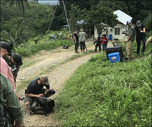
PrecisionHawk conduced as much preparation as it could before traveling to the Philippines, including identifying the equipment and network connections. "The production company couldn't give us an exact picture of what to expect on the ground," says Matt Tompkins, PrecisionHawk's team leader and director of flight operations. "One of the things we did was to study terrain models based on satellite data. They then determined where they could take off and land from."
PrecisionHawk's team mounted a LIDAR sensor to the base of the drone, which fired its LIDAR pulses at the ground at a rate of 100 pulses per second. The system then measured the amount of time it took for the light to bounce back up from the jungle surface, Tompkins says.
On the ground, PrecisionHawk set up a base station with satellite connectivity and GPS functionality, as well as a computer for interpreting the collected data. Due to the fast planning and the remote location, the team needed to be versatile. Jill Wrenn, PrecisionHawk's director of operations for LIDAR, was the onsite processor to create a map from the data. "The first day there," she recalls, "we needed more access to GPS satellite, so we had to call our GPS company to add on worldwide access to satellite. Thankfully, it only took a day to figure that out," since the team had only days to complete their work.

During the actual flights, the crew required real-time control of its location. "My role on the ground was to plan a flight, and that data is sent to the aircraft over a 2.4 GHz transmission," Tompkins explains. Once the drone was in the air, it transmitted data back to the base station via its 2.4 GHz connection, forwarding both its GPS-based location and its elevation. At the same time, LIDAR data from the drone was captured on a SIM card, after which Wrenn processed that data on the computer once the drone returned to the ground.

The LIDAR data enabled Wrenn's team to create a map of the terrain without vegetation, as well as detect a series of potential roads and pathways that might have been used by the Japanese military. They were then able to present the production crew with digitized images showing those details that could indicate where treasure had been buried more than 70 years ago.
The team did not find the treasure they sought, but they did discover indications that it might still be there—and the project gave PrecisionHawk an opportunity to test what it could do in a short period of time on challenging terrain. "It was super-fun, and those guys [the production crew] were awesome," Tompkins says. "We found enough to let them see what they wanted," Young adds, "and our experience prevented the unknown."
