Nov 04, 2016Seattle-based underground utility maintenance and inspection company Bravo Environmental is burying a radio frequency identification tag at each location it accesses underground, in order to create an automatic record of what occurred, as well as where and when, and to enable personnel and customers to locate a particular pipe, conduit or other underground equipment after it is covered. The company is using the InfraMarker's asset-management solution, provided by Berntsen—which consists of the RFID tags, an iOS- and Android-based app, and geographic information systems (GIS) software supplied AmigoCloud—to manage data regarding each marker's location.
Bravo Environmental operates vacuum trucks to clean sewer lines and catch basins, and also provides excavation (commonly referred to as potholing) by digging holes to search for buried pipes or other infrastructure, in advance of construction projects. This task, known as subsurface utility engineering (SUE), is carried out so that when contractors begin a project—as building a road or digging a trench, for example—they can avoid inadvertently striking an existing underground pipe, cable or other asset.
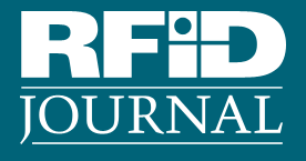
In May 2016, Bravo began burying approximately 50 InfraMarker tags underground near Interstate 90 in Bellevue, Wash. Each tag contains an off-the-shelf EPC Gen 2 ultrahigh-frequency (UHF) RFID transponder, as well as a magnet detectable by means of a magnetic locator. The company determined that Berntsen's markers could easily be scanned by an RFID reader or magnetic locator after the project was complete, says Kemp Garcia, Bravo Environmental's project manager, and is now installing the markers wherever it digs.
The SUE excavation process consists of evaluating an area at the request of an engineering firm, with workers visibly searching for manholes or other signs of utilities aboveground and then excavating to seek the horizontal and vertical locations of a piece of infrastructure, such as a gas line, water pipe or electric cable. Before Bravo Environmental began using the InfraMarker system, its employees manually recorded the locations of whatever they found underground, took pictures of those items and forwarded that data to the office so that the information could be packaged and shared with the customer. "Our history," Garcia says, "has been sending crews out with a spreadsheet," who then recorded the size, depth and type of utility they located. However, he adds, this process can be slow and still leaves room for error.
For years, Garcia reports, he has been seeking a more automated solution that could precisely identify where underground infrastructure exists, so that it could easily be found again. Although there are other RFID solutions for this application, he notes, some customers—such as engineers, utility employees or contractors—lack an RFID reader on hand to access data, or the ability to easily access the information in the field.
The benefit of InfraMarker, Garcia explains, is that it utilizes two technologies: RFID and magnetic. If someone does not have an RFID reader, he or she can access location data by using a magnetic locator, though such a device would not provide an identifier. Therefore, he says, if multiple markers are in close proximity to one another, RFID would be a better way to locate a specific piece of infrastructure.
Berntsen manufactures several different markers, with either an Omni-ID Dura 3000 RFID tag or an RFID transponder made by Confidex, according to Lee Nelson, the company's business-development director. "The benefits of InfraMarker," he states, "are twofold: increased locating performance, thanks to the combination of InfraMarker's patented magnet-RFID tag and visual evidence, and the real-time transfer of data, which speeds data collection and reduces errors in data collection."
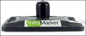
A user can read the tag via a Technology Solutions (UK) Ltd. (TSL) 1128 Bluetooth UHF RFID reader with a cradle for a smartphone loaded with the InfraMarker app. The app can utilize the phone's GPS location data to record a marker's longitude and latitude. A phone's GPS unit, however, is not as precise as a GPS device designed specifically for industrial purposes. As such, the app can also use the phone's Bluetooth radio to access an industrial GPS device—such as a Trimble R-1 global navigation satellite system (GNSS) receiver—to determine a more precise location.
When Bravo's workers dig a hole to search for utilities, they identify what they locate and then insert an InfraMarker tag about 12 inches below the surface. Staff members in the field can use the handheld with a smartphone to write data to the marker tag. The InfraMarker app on the iOS or Android phone then captures the tag's ID and other information written to the tag, and forwards that data to the AmigoCloud software. Workers use the app to enter a description of the area, along with the type of utility found at the site (a gas pipe, for instance), the owner, any pictures or video footage of the asset and area, and notes regarding conditions. The device forwards the tag ID and related data to the AmigoCloud software, which likes that information together.
Employees can easily input the data into the system by using the app's dropdown menu, Garcia explains. For instance, upon identifying something underground, workers select a prompt to specify the type of utility and add related descriptions as necessary. "InfraMarker provides a very simple pull-down menu to minimize error and maximize efficiency," says Mike Klonsinski, Berntsen's executive VP.
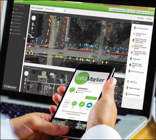
Once the phone forwards the data to the AmigoCloud software, Bravo Environmental's management can use InfraMarker software running on a computer to view that data immediately. Thus, Garcia says, even as the markers are being laid underground, he can view the work being performed in real time, via the software.
The solution provides a value-added service for customers, Garcia says, which is the key benefit. The data collected can be shared with any authorized parties, such as engineering firms, contractors or other companies that may need to dig underground, and Bravo Environmental can control access to that data.
What's more, Klonsinski says, third-party companies that might need to document any damage in the event of an accident can use the technology to do so. If their digging causes a pipe to become damaged, for instance, they could view the InfraMarker URL printed on the marker, visit the website to view information about what is located there and report what damage occurred. However, Garcia notes, the markers' placement 12 inches below the surface is also intended to serve as a visual marker that alerts individuals digging in the area that a utility exists somewhere below that marker, in order to prevent accidents. "The physical marker in the field is a verification that you are at the right point," he says, "and a fail-safe for field crews."
Bravo Environmental expects that the technology's use will earn the company more jobs, since it gives Bravo a way to automatically provide data regarding what its crews found in the field, or the work they accomplished there. The company has installed a total of about 100 markers to date, and has contracted for a project in which it will install another 150 underground.
Berntsen first released the InfraMarker system in July 2014. The Auburn Geospatial Research & Applications Center (GRAC) researched the technology and found that it took individuals seeking a particular marker an average of 2.5 minutes to locate it using an RFID reader, as opposed to 14 minutes using GPS data (see InfraMarker Adds GPS, Cloud Services to Manage Buried Assets).
A variety of businesses seeking to track underground infrastructure have tested or deployed the InfraMarker system, Nelson says. The testing companies' feedback led Berntsen, in September 2016, to release an updated version of the InfraMarker system that provides stronger GIS support, as well as an iOS version, greater customization capability and expanded access control.
