
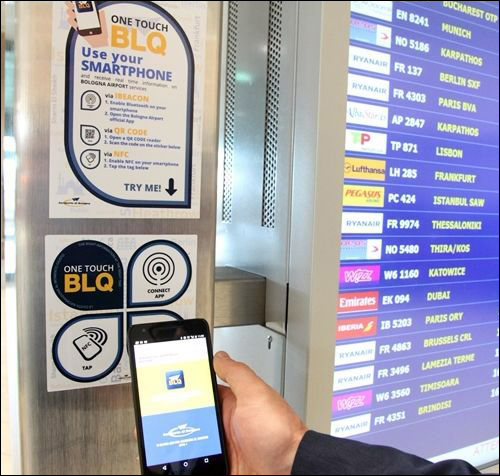
Jul 19, 2016Bologna Gugliemo Marconi Airport has launched a Near Field Communication (NFC) RFID and Bluetooth beacon solution that allows commuters to access content about the airport, as well as the city beyond, via their mobile phones or other smart devices. The One Touch BLQ system—which uses the airport's BLQ app in conjunction with Connecthings content-management software, NFC RFID labels and Bluetooth beacons—was taken live early last month. The airport has installed signs containing NFC RFID labels (printed with QR codes) in some parts of its facility, and beacons in others that transmit data directly to passengers' devices running the airport app.
Connecthings is now in discussions with Bologna officials to enable the city's app to provide bus information at bus shelters, and at other sites around the city as well.
Bologna Gugliemo Marconi Airport, which served nearly seven million passengers flying through the airport last year, has one runway, 24 gates and 10 security checkpoints. Silvia Lombardi, Bologna Airport's IT and innovations manager, says the facility wanted to provide a smart and modern way for terminal visitors in transit to receive contextualized information, and to improve their overall passenger experience.
The Connecthings solution enables the airport to employ a variety of technologies for multiple use cases. In some situations, for instance, passengers want to receive push notifications on their devices as they move through the airport (at check-in, for example, nearly every traveler would appreciate receiving information regarding pending flights). Sometimes, only some passengers want specific information, such as instructions indicating how they should put their bags through screening. In that case, signs fitted with an NFC tag and a QR code allow those individuals to access the information they seek. For instance, if a passenger is in the baggage-claim area, she can access data about the carousel she is looking for, but only if she requests such information by using the signage's NFC or QR-code functionality.
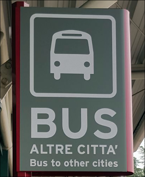
The airport tested a beta version of the solution in April 2016, and then installed 50 beacons last month (Connecthings declined to name the beacon hardware provider), along with 85 NFC RFID labels printed with QR codes. In addition, the airport is installing 15 more NFC labels at local bus stops near its facility that will enable users to access flight information.
When a passenger arrives at the airport's check-in area and her smartphone comes within range of a beacon, the phone receives the beacon's ID number and launches the BLQ app. The app, which can be downloaded from the iTunes and Google Play websites, then displays content related to that location. For instance, it can invite the user to learn where the proper check-in counter is for her flight, as well as the boarding gate and boarding time.

As the passenger passes other areas, beacons can trigger the displaying of information related to those locations. She can also use the NFC tags and QR codes posted around the airport to call up information, such as a video explaining how to pass through security checkpoints. The beacons installed at bus stops around the airport can facilitate travelers' access to bus schedule information.
"The greatest benefit is surely to help passengers receive the right information at the right time, through a smart and very commonly used device," Lombardi says. "By simply walking around the terminal, users receive the information they need in order to serenely go through all steps of their journey."
The airport has not yet been able to collect sufficient data to measure the system's results, Lombardi says. Nonetheless, she notes, "We know, for sure, that the solution will help to facilitate the passengers' journey through the terminal."
The initial phase of the deployment is centered on providing information about flights, and about procedures in place at the airport, such as security lines. In the future, the technology will also offer content for promotional purposes, such as information related to stores, and to sites in Bologna beyond the airport.
According to Laetitia Gazel Anthoine, Connecthings' CEO and founder, the French technology company was launched in 2007 as a content-management software provider for mobile applications used in public places, with the intent of linking location-based content to phone users. The company offers its ADTAG content-management software to cities, public transportation providers, shopping centers and stadiums on a software-as-a-service (SaaS) basis, and has carried out deployments of 120,000 beacons or more throughout 27 cities.

Connecthings has also deployed 25,000 Bluetooth beacons, in addition to NFC RFID labels with QR codes, on shelves in stores across France, in order to enable users of the Mappy online mapping service to view location-based content. Companies or agencies can use the firm's ADTAG system or software developers kit (SDK) to receive contextual data based on a read event that then prompts a notification from a company's or agency's app that is relevant to that location.
In other cities, Connecthings' customers are using the ADTAG content-management software with their own apps to deliver information. For instance, if a resident has an app for the bus system, he could receive a notice upon tapping his phone against an NFC tag at a bus stop, thereby indicating when the bus in which he's interested will arrive. If there will be an extended wait before the vehicle shows up, the system could enable another app, such as one for a bike-sharing program, to display the nearest bike-rental station as an alternative mode of transportation. Conversely, Anthoine says, the system could share bus information with an individual planning to rent a bike, if the weather forecast indicated that rain was on its way.
