
Jun 13, 2016CDO Technologies has commercialized its ultrahigh-frequency (UHF) RFID solution for tracking information regarding street cuts—openings in roads that are typically made by utility companies to repair cables and pipes underground. The solution, known as RoadTag, was commercially launched last year, and several dozen cities and agencies are now preparing to adopt the system to monitor road cuts, as well as some roadside assets, in order to provide information to workers in the field. Denver and Colorado Springs recently announced deployments of the technology, while Los Angeles intends to employ the system to track sidewalks and bicycle lanes citywide, as they are being installed.
Dayton, Ohio, was the first municipality to adopt an early version the RoadTag, (see RFID Speeds Up Roadway Repairs), with ruggedized UHF RFID tags embedded in the roadway where cuts had been made and then restored using concrete and asphalt. Every year, the city investigates 70 to 100 complaints about poorly restored road cuts, and for sections where an RFID tag was installed, the technology enables those who respond to quickly access information about who made each cut and carried out the restoration, so that any necessary repairs can be quickly scheduled with the appropriate parties.
During the past three years, the Dayton deployment afforded CDO an opportunity to test the technology in a real-world environment. The tags have been subjected to rain, snow, ice and heat, as well as the application of cement and steamroller pressure.
The greatest challenge now is not in the technology's effectiveness, says Robert Zielinski, CDO Technologies' director; CDO knows it works. Rather, it is the operating procedures in regard to the tags' use: How are they distributed to contractors, for instance, and how much data should be associated with each tag?
"We decided generalizing a solution made sense," Zielinski says, adding that those acquiring the technology must consider not only the system's technical aspects, but also the politics of how it is used. And, he says, users need to know that the technology "is not meant to replace bodies." Instead, it allows public works and utility companies to divert labor to more productive projects, such as following up with complaints and watching for potential future failures on the roads. What's more, it can improve a city's public image by enabling it to become more responsive to the public.
Using the learnings of the first installation in Dayton, CDO released a commercially packaged solution in October 2015. The system consists of 5,000 UHF RFID Technologies ROI (TROI) tags to be embedded in roadways, as well as CDO's RoadTag software and one each of a handheld and desktop reader.
Dayton has handed out approximately 9,200 tags to utilities since 2013, according to Andrew Marks, an engineer in training for the city. Most are used by Dayton's natural gas provider, Vectren. Because Vectren is divided into three branches, the city provides tags encoded with a different ID number for each branch, and also links the month and year with each tag in its own software as the tags are distributed to the utility.
"The more we install them, the more people will be using them," Marks says, as the city's road-inspection crews begin to expect the tags to be in place for accessing data.
The next phase, Marks says, is to link each tag ID with the installation location on a digital map as the tags are installed. That could be accomplished by collecting location data from a handheld as it reads the tags being embedded in road cuts. Administrators could then easily view the tags' locations in the software. The city has applied for a grant that would help to pay for that expansion of the system.
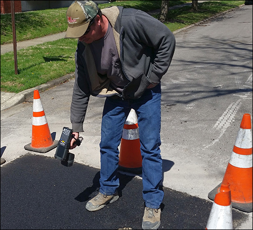
Zielinski recalls an inspector at Dayton who received a phone call regarding a problematic section of roadway that had been cut and restored. The inspector reported that he then visited the site equipped with a handheld reader, immediately captured the permit number and who performed the work, and placed a call to the contractor while walking back to his truck. By the time he climbed into the vehicle, the repair work had already been scheduled.
In October 2015, CDO announced that Denver's public works department was evaluating the RoadTag for use with its approximately 8,000 street cuts each year on 6,100 lane-miles of roadway (see RFID News Roundup: CDO Technologies' RoadTag Hits Denver Streets).
Last month, Colorado Springs made a similar announcement. The city has 5,688 road miles that must be maintained, repaired and investigated during failures or damage, says Robin Tisdale, an engineering technician for the city's public works operations and maintenance division. The greatest challenge that cities face without having an automated system in place for collecting data about road work, Tisdale explains, is the amount of time employees must spend researching permits to determine what has previously taken place at a particular road cut.
"Using RFID technology, we can quickly identify and greatly enhance our response times to any excavation failures or emergencies," Tisdale states. "We are now able to easily determine warranty periods for all road cuts. We anticipate a dual-purpose benefit for both inspectors in the field and office personnel."
Colorado Springs issued approximately 3,568 permits for road work last year. Each permit represents at least one cut in the roadway. The city's public works division now provides encoded tags for contractors, which it issues with all roadwork permits.
"We previously spent a large amount of time researching failures in the roadway—tracking down who is responsible, age of street cut, and warranty information," Tisdale says. "Our goal is to have a tag in each cut made in the road."
The ways in which the RoadTag solution is used, Zielinski says, will vary from one community to another. "Every city is slightly different," he explains, "so what they program on the tags is going to be slightly different, too." In many cases, a municipality's road department deploys tags according to specific vendors' needs, then hands out the tags for them to use during a specific month. The vendors can distribute those tags to contractors or use them with their own crew. As they complete each project, they can drop the corresponding tag in the area of work and cover it with pavement. Road inspectors will then be able to read a given tag in order to learn which company was responsible for that project, along with the month and year in which it was completed.
Some cities could write more information to the tags, such as building permit numbers, to associate a tag with a specific project.
"At this point, they don't write to the tags" in the field, Zielinski says, though the city could opt to do so in the future. At least one state's department of transportation is looking into the use of RoadTag RFID tags for inspectors to collect and write data related to bridge inspections, thereby creating a record that other authorized parties in the field could access, even if they lack an Internet connection.
Increasingly, Zielinski notes, each city has its own use case beyond the simple tracking of road cuts. For instance, tags could be installed in the middle of intersections and be associated with streetlights so that any work performed on a particular streetlight could be updated and associated with the corresponding tag so that city workers can then access such information as maintenance or inspection records. Additionally, several cities are considering using the technology to identify specific city trees, guard rails, handicapped ramps and sidewalks to, for instance, confirm that an inspector was there, or that other services had been provided, by whom and when.
CDO works with several other companies besides TROI to obtain its RoadTag RFID tags, Zielinski says, though its lineup of suppliers may change depending on the asphalt material through and around which the tags must transmit. On the East Coast, for instance, some state, county and city agencies are incorporating recycled and shredded rubber tires in asphalt, including fragments of the steel belts built into such tires. "We are working with various hardware providers," he says. The company also uses a variety of reader brands and models, including Alien Technology's ALR-9650 fixed RFID reader with an integrated antenna, which can be installed on desktops (for commissioning tags, for instance), and Zebra Technologies' MC9190-Z handheld reader.
Currently, the RoadTag software—with the primary function of collecting and storing data linked to each tag ID—resides on the administrator's PC and stands alone. "We've really worked on making it simple," Zielinski says, adding that if cities want to integrate the software with a permitting or inspection system in the future, CDO can provide that functionality.
Los Angeles is the latest adopter of the RoadTag system. L.A. is using the RFID solution to identify sidewalks and bike lanes being constructed throughout the city, to meet an American Disabilities Act (ADA) ruling to provide more access for pedestrians and cyclists. The city intends to distribute the tags to contractors in the future.
